The southwestern United States is dry and is utterly dependent on the Colorado River for fresh water. There are two major dams on the river, which create artificial lakes. One is the Boulder (Hoover) Dam, near Las Vegas, which generates hydroelectric power and creates Lake Mead. On one side is Nevada and the other Arizona. The other is Parker Dam, with California on one side and Arizona on the other. From Parker Dam a canal, supported by pumping stations, diverts much-needed water water westward to Los Angeles and San Diego.
So much water is taken from the Colorado River that, by the time it reaches the sea in Mexico, there isn't much left of it. Can you believe that the trickle of water, no more than a creek, in the following images from Google Street View is the mighty river that sustains America's southwest and once carved the Grand Canyon?


In the following satellite image from Google Earth you can see how water from the river, along the length of it's flow, makes the desert bloom for agriculture.

Clearly there must have been exceptional circumstances for the Colorado River to carve the Grand Canyon. What happened is fairly obvious. There have been multiple ice ages, exactly how many depends on who you ask.
An ice age, which usually lasts several thousand years, begins when it gets cold enough that the snow of one winter hasn't completely melted when the following winter begins. Snow piles up year after year, decade after decade, and century after century. The snow at the bottom is compressed into ice by the weight of the snow above it. This results in a vast sheet of ice that might be 1-2 km thick. The thickness is limited only by the altitude of the clouds from which the snow falls.
The rotation of the earth exerts more force on the side of the sheet of ice that is closest to the equator. This pulls the sheet of ice and is why glaciers tend to move in the direction of the equator. Any object that is wide enough will be pulled toward the equator.
This formation of vast glaciers on land takes water out of the oceans so that sea level drops during the ice ages, and some seafloor across the world becomes dry land. This is how the ancestors of the native Indians of the western hemisphere walked across from Asia. It is also how people settled Japan and how the Legend of Atlantis got started.
When the ice age ends all of this ice melts. This, of course, produces a great rush of water. This explains the flood story in the Bible. At the end of every ice age most of the water from the glaciers that had been across the western United States took the same route to the sea and that is, over a long period of time, what formed the Grand Canyon.
There is actually a model of how the Grand Canyon operates not too far from here in Letchworth State Park, in New York State. The Genesee River flows through the canyon but certainly didn't form it. The canyon is actually one of the Finger Lakes, formed by moving glaciers as described above, but was too high to fill with water. The river flowed through it afterward. The following image is from Google Earth.

We can tell that the canyon of Letchworth State Park was formed by moving ice, not by flowing water, because of the amount of loose rock. This is from chips off the rock strata by moving ice, not flowing water. The following image is from Google Street View.

If a river has twists and turns like that it means that it's a young river, formed after the end of the last ice age. Moving glaciers typically obliterate everything on the landscape, except mountains, and the drainage pattern starts over again after the end of the ice age.
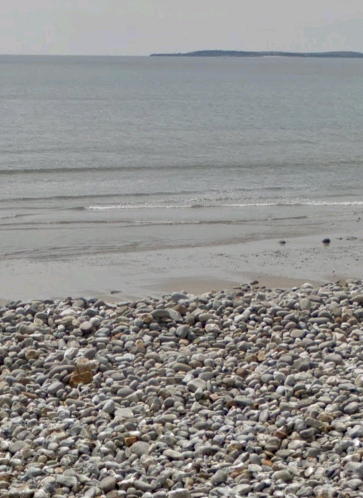
Waves or flowing water eventually break rock down into sand, but it takes a very long time. The following image from Google Street View of a beach in Wales shows rock fragments in the foreground and sand in the background. The pieces of rock were broken off the rock strata by sliding glacial fragments at the end of the last ice age and the sand is from long before that. I have a feeling that the tremendous weight of the glacier during the ice age might grind rock fragments into sand.
This means that sand cannot possibly form on river beaches. This sand on Beaver Island was obviously brought in by truck. Image from Google Earth.

No comments:
Post a Comment