Thursday, April 27, 2023

Bavaria

The southeastern-most of Germany's states is Bavaria. It's largest city is Munich. Although expensive, Munich is globally-known for it's high quality of life. The Alps are visible from Munich.

During the Reformation, Munich remained devoutly Catholic. The center of Munich, it's main square, has always been Marienplatz, with a statue of Mary called the Mariansaule, at the top of a column.

The following views of central Munich begin in Marianplatz. The stone building with the spires is the city hall. The church with the orange roof is the Frauenkirche. Munich began in the 12th Century and the church in the 13th Century. But the City or Town Hall is from the 19th Century.

There are multiple scenes following. To see the scenes, after the first one, you must first click the up arrow, ^, before you can move on to the next scene by clicking the right or forward arrow, >, After clicking the up arrow, you can then hide the previews of successive scenes, if you wish.

https://www.google.com/maps/@48.1372382,11.575411,3a,75y,110.31h,90t/data=!3m8!1e1!3m6!1sAF1QipPL32K1_z5U9enpxv65mKanoCcvfJKcLw1WJDpw!2e10!3e11!6shttps:%2F%2Flh5.googleusercontent.com%2Fp%2FAF1QipPL32K1_z5U9enpxv65mKanoCcvfJKcLw1WJDpw%3Dw203-h100-k-no-pi-0-ya32.01859-ro-0-fo100!7i8704!8i4352

Here is more of central Munich, beginning at the Karisplatz.

https://www.google.com/maps/@48.1402266,11.5660894,3a,75y,173.99h,90t/data=!3m7!1e1!3m5!1sdDDl52fQ3RjUeUPWcdOyCw!2e0!6s%2F%2Fgeo1.ggpht.com%2Fcbk%3Fpanoid%3DdDDl52fQ3RjUeUPWcdOyCw%26output%3Dthumbnail%26cb_client%3Dmaps_sv.tactile.gps%26thumb%3D2%26w%3D203%26h%3D100%26yaw%3D175.98428%26pitch%3D0%26thumbfov%3D100!7i13312!8i6656

This is the area, to the north of central Munich, known as Schwabing.

https://www.google.com/maps/@48.163346,11.5851855,3a,75y,304.5h,92.93t/data=!3m8!1e1!3m6!1sAF1QipM0E-NK8y_9s4qoqzR4U_RqaqPRrNa-riuXcOCh!2e10!3e11!6shttps:%2F%2Flh5.googleusercontent.com%2Fp%2FAF1QipM0E-NK8y_9s4qoqzR4U_RqaqPRrNa-riuXcOCh%3Dw203-h100-k-no-pi-2.9338646-ya124.49999-ro-0-fo100!7i8704!8i4352

Bavaria is known for Neuschwanstein Castle. When Bavaria was a kingdom, in the late 19th Century, King Ludwig II was fascinated by the Middle Ages and went all-out to build his dream home, regardless of budgetary concerns. Although he never lived in it himself for long, it is now one of the most famous buildings in the world and was the architectural model for Disney World.

https://www.google.com/maps/@47.5571747,10.7487135,3a,75y,66.75h,90t/data=!3m8!1e1!3m6!1sAF1QipOhxCosdYaOVRRh0JkZECnuvaaVkDdm_oz9ohkG!2e10!3e11!6shttps:%2F%2Flh5.googleusercontent.com%2Fp%2FAF1QipOhxCosdYaOVRRh0JkZECnuvaaVkDdm_oz9ohkG%3Dw203-h100-k-no-pi-0-ya233.51555-ro-0-fo100!7i7168!8i3584

There used to be walls around the old city of Munich and one of the remaining gates is the Sendlinger Tor.

https://www.google.com/maps/@48.1335831,11.5672058,3a,75y,15.68h,90t/data=!3m7!1e1!3m5!1sFJTmRQUz6mZNWhxj9MeySg!2e0!6s%2F%2Fgeo2.ggpht.com%2Fcbk%3Fpanoid%3DFJTmRQUz6mZNWhxj9MeySg%26output%3Dthumbnail%26cb_client%3Dmaps_sv.tactile.gps%26thumb%3D2%26w%3D203%26h%3D100%26yaw%3D10.608776%26pitch%3D0%26thumbfov%3D100!7i13312!8i6656

To the north of Munich, this is the Schleissheim Palace, from the 18th Century.

https://www.google.com/maps/@48.2487878,11.5609997,3a,75y,116.54h,90t/data=!3m8!1e1!3m6!1sAF1QipPnkNLShxQ4lNI6L57qL46wjm38BowClZu8FLyJ!2e10!3e11!6shttps:%2F%2Flh5.googleusercontent.com%2Fp%2FAF1QipPnkNLShxQ4lNI6L57qL46wjm38BowClZu8FLyJ%3Dw203-h100-k-no-pi-0-ya126.86988-ro-0-fo100!7i5472!8i2736

Another Munich palace is the Nymphenburg.

https://www.google.com/maps/@48.1582644,11.5032362,3a,75y,89.41h,90t/data=!3m8!1e1!3m6!1sAF1QipOw_-OxDUIXA7DBVRNYt4CZTxjJkDvhGwbX9-LX!2e10!3e11!6shttps:%2F%2Flh5.googleusercontent.com%2Fp%2FAF1QipOw_-OxDUIXA7DBVRNYt4CZTxjJkDvhGwbX9-LX%3Dw203-h100-k-no-pi-0-ya58.119816-ro-0-fo100!7i2999!8i1049

The second-largest city in Bavaria, after Munich, is Nuremberg. While Munich stayed Catholic when the Reformation came, Nuremberg went wholeheartedly Protestant. This is why the German-speaking states of central Europe didn't become a united country until 1871. There was so much division between Protestant and Catholic.

The Holy Roman Empire, which lasted for a thousand years, didn't really have a capital city. It's focus of administration usually depended on where it's emperor was from. But if any city could be said to have been the center of the Empire, at least for most of it's history, that city would likely be Nuremberg. The following scenes begin in Nuremberg Castle, around which the vast empire revolved. The famous artist Albrecht Durer lived right next to the castle.

https://www.google.com/maps/@49.4579588,11.0754898,3a,75y,126.23h,90t/data=!3m8!1e1!3m6!1sAF1QipPPe20L3oxpzNrs624CtO1M4X7huMf8ikjIOn4-!2e10!3e11!6shttps:%2F%2Flh5.googleusercontent.com%2Fp%2FAF1QipPPe20L3oxpzNrs624CtO1M4X7huMf8ikjIOn4-%3Dw203-h100-k-no-pi-0-ya305.42474-ro0-fo100!7i10240!8i5120

This is the district of Nuremberg known as Furth.

https://www.google.com/maps/@49.4773944,10.9891794,3a,75y,1.68h,120t/data=!3m8!1e1!3m6!1sAF1QipP3WbmxC8vwHaXSf2VDAxDIU5-av7k-aynZT7SU!2e10!3e11!6shttps:%2F%2Flh5.googleusercontent.com%2Fp%2FAF1QipP3WbmxC8vwHaXSf2VDAxDIU5-av7k-aynZT7SU%3Dw203-h100-k-no-pi-30.000002-ya1.6770833-ro-0-fo100!7i5472!8i2736

Another historic city in Bavaria is Augsburg. This is a very old city, going back to the time of Jesus. The peace treaty between Catholics and Protestants, allowing rules of principalities to choose either Catholicism or Lutheranism is called the Peace of Augsburg. The main creed of Lutheranism is the Augsburg Confession.

https://www.google.com/maps/@48.3729697,10.8961797,3a,75y,108.1h,90t/data=!3m8!1e1!3m6!1sAF1QipPyFkFm5crEyoCexkWLfxpAx7C9s2MXu6uEOx14!2e10!3e11!6shttps:%2F%2Flh5.googleusercontent.com%2Fp%2FAF1QipPyFkFm5crEyoCexkWLfxpAx7C9s2MXu6uEOx14%3Dw203-h100-k-no-pi-0-ya55.205235-ro-0-fo100!7i8704!8i4352

Finally, there is Regensburg. This very old city was the site of the parliament (diet) of the Holy Roman Empire. It became a strongly Protestant city at the time of the Reformation. The city's cathedral was begun in the 13th Century. Here is the center of the oldest part of the city.

https://www.google.com/maps/@49.0184288,12.0969141,3a,75y,164.46h,90t/data=!3m8!1e1!3m6!1sAF1QipO5GTCA_kItBvOEgJSaRnyorgNhdtB912bsv9ly!2e10!3e11!6shttps:%2F%2Flh5.googleusercontent.com%2Fp%2FAF1QipO5GTCA_kItBvOEgJSaRnyorgNhdtB912bsv9ly%3Dw203-h100-k-no-pi8.30581-ya169.66112-ro0.76271623-fo100!7i7200!8i3600

Remembering The Holy Roman Empire

On the subject of Nuremberg today how about a look back at the Holy Roman Empire. While it was not an "empire", in the traditional sense, it has had a tremendous influence on history simply because it lasted for a thousand years. 

It was formed by the Catholic Church in an effort to rein in the wayward eastern Christians, who would later split away to form the Eastern Orthodox Church. Charlemagne was crowned as it's first emperor on Christmas day of the year 800. The Holy Roman Empire would last until finally brought to an end by the conquests of Napoleon.

But it grew beyond the control of the pope and, if anything, was more of a rival to the Catholic Church than an ally. I consider it as no coincidence that the Protestant Reformation, which split the Catholic Church, began in the heart of the Holy Roman Empire. It's boundaries fluctuated and, despite the name, usually didn't include Rome. It didn't have an official capital but if any city can be described as the heart of the Holy Roman Empire it was Nuremberg.

Here is a link to the posting "The Far-Reaching Legacy Of The Holy Roman Empire":

www.markmeeksideas.blogspot.com/2016/04/the-far-reaching-legacy-of-holy-roman.html?m=0

Earth's Rotation And Water Depth

Here is a question that I have wondered about. What would the map of the world look like if the earth was not rotating?

The spin of the earth produces centrifugal force. The earth is solid while the oceans are fluid. This means that the centrifugal force should pull water toward the equator so that the seas should, on the average, be deeper in the tropics than at higher latitudes.

We can see this centrifugal force in the movement of glaciers during the ice ages. Glaciers begin to form when the temperature gets cold enough that the snow of a winter hasn't entirely melted when the snow of the next winter begins. Snow piles up year after year, decade after decade, and century after century. The snow is compacted into ice by the weight of the snow above it. The result is a vast sheet of ice maybe one or two km thick, limited in thickness only by the altitude of the cloud from which the snow falls.

The centrifugal force of the earth's spin is greatest toward the equator. This means that there is a difference in the centrifugal force on the glacier, with the greatest force closer to the equator. This has the effect of pulling the entire mass of ice toward the equator, and this is why glaciers move.

The spin of the earth also has a pronounced effect on the winds. The prevailing winds on earth are alternating bands of prevailing west or east winds, while north and south winds are intermittent. Circular storms like hurricanes pick up their cyclical motion from the spin of the earth.

So if the spin of the earth affects glaciers and winds then shouldn't it have an effect on the water in the oceans? It does affect ocean currents but if the centrifugal force pulls glacial ice toward the equator, although the sheet will move only if it is vast enough for there to be enough difference in the centrifugal force closer to and further from the equator to move it, then shouldn't it also pull the water of the oceans toward the equator?

This would mean that, on the average and with other factors being equal, water would be deeper around the equator than at higher latitudes. This in turn would mean that there would be less land and more water composing the earth's surface around the tropics than there would have been if the earth were not spinning.

Indeed the deepest points of both the Indian and Pacific Oceans are within a few degrees of the equator. The deepest point of the Atlantic Ocean is about 18 degrees from the equator.

The surface of the entire earth is about 72 percent water and 28 percent land. It is true that the distribution of land on earth is very uneven and follows no pattern. The vast majority of the earth's land area is in the northern hemisphere so that the northern hemisphere is about half land while the southern hemisphere is about 90 percent water.

But the equator is between the northern and southern hemispheres and we might have the expectation that the surface over which the equator passes would be about 72 percent water and 28 percent land. But the percentage of land would be expected to be less, and that of water greater, if the centrifugal force of the earth's rotation did, in fact, pull water toward the equator.

This is indeed the case as the surface over which the equator passes is only about 21.4 percent land, and 78.6 percent water. The four significant land masses over which the equator passes are South America, Africa, Sumatra and, Borneo.

The light blue on the following map from Google Earth is the vast shallow area of sea between Indonesia, Malaysia, Vietnam and, Thailand. Might this have been land if the earth didn't spin, or rotated more slowly so that there wouldn't be as much centrifugal force to draw water to the tropics?

The following map from Google Earth makes it seem as if Australia and Papua New Guinea are really one land mass until the light blue shallow sea flooded in because the centrifugal force of the spin of the earth pulled water toward the equator.

There is a wide area of shallow sea off the Gulf Coast of Florida. If the earth didn't spin, or spun much slower, might Florida have much more real estate than it does now? Image from Google Earth.

On the other hand, what if the earth rotated more slowly so that days were longer? Might Britain and Ireland be joined to continental Europe, as they once were, until the shallow sea separating them was formed by glacial movement? Because the spin of the earth wouldn't be pulling so much water to the tropics. Image from Google Earth.

The spin of the earth is very significant, relative to it's scale. A point on the equator is moving eastward at about the speed of sound. It actually seems that there should be even more difference in water depth between the tropics and the higher latitudes.

The earth actually does bulge at the equator due to the centrifugal force of rotation. The equatorial diameter of the earth is a little bit more, relatively speaking, than the polar diameter. If not for this bulge, if the earth were a perfect solid, and water was drawn to the tropics by the force of the spin, then there may well have been no land at all around the equator.

The fact that the earth bulges like this is what I consider proof that there must be magma, hot molten rock, beneath the surface all over the world. This would be a requirement for my geologic theory as described in the compound posting "The Story Of Planet Earth", on the geology blog, www.markmeekearth.blogspot.com . This theory, based on Continental Asteroids and the emergence of magma from below, leaves no major feature of the earth's surface, whether on land or the seafloor, unexplained. It has indeed recently been confirmed that there is a layer of magma, about 150 km down, across the entire earth.

The Historical Roots Of Mario

I cannot see written anywhere about how rooted the Nintendo mascots of Mario and Luigi are in history. This is a primary example of how important history is to us. We resonate with things that are rooted in history, even if we are not consciously aware of it. Everything about this is very cleverly rooted in the history of the Mediterranean area of Europe.

Mario and Luigi are twin brothers, although not identical twins. This gives them a lot in common with Romulus and Remus, the founders of Rome. Romulus, or one of his followers, killed Remus so that Romulus got Rome named for him. Mario's red and Luigi's green obviously represent the two sides of the modern Italian flag. 

Mario and Luigi are plumbers by trade. This is a further link with Rome. Plumbers today are so-called because the Romans made pipes out of lead which, unlike iron, doesn't rust. The Latin word for lead was "plumbum", which is also why the chemical symbol for lead is Pb.

Mario and Luigi live in the Mushroom Kingdom. On a map, Italy is shaped like a mushroom with the two peninsulas in the south being the roots. The Mushroom Kingdom has "Warp Tubes", which can transport a person to other places, even distant worlds. This represents the era of Christopher Columbus, and also Galileo's telescope.

The palace of the ruler of the Mushroom Kingdom, Princess Peach, is built on a hill. This represents Mario and Luigi being a reconciled version of Romulus and Remus, who argued over which hill Rome should be built on. Mario regularly rescues Princess Peach, just as Romulus had once rescued his brother. The palace is white, the spires are red and, the grass is green, again the Italian flag.

Mario looks like a southern Italian, except that he has blue eyes. This is done to cleverly incorporate northern Italians in too.

There is a program about the "Odyssey" of Mario. "The Odyssey" is a vital part of the classic literature of ancient Greece, which preceded Rome. The major cities of southern Italy, although not Rome, began as Greek settlements.

The city that is now called Istanbul was actually founded by the Roman Emperor Constantine. It was named Constantinople and was to be the capital of the eastern half of the Roman Empire. In 1453 the city was conquered by the Ottomans and renamed as Istanbul.

The palace in the Mushroom Kingdom is based on the Topkapi Palace. This was the palace of the Ottoman Rulers, before they later moved to the Dolmabahce Palace on the waterfront. Image from Google Street View.

The tower of the palace in the Mushroom Kingdom was clearly based on the Galata Tower, also in Istanbul. This tower was actually built by settlers from Genoa in what was then-called Constantinople. Image from Google Street View.

This was obviously very carefully thought out by Nintendo. It shows the importance of history. Las Vegas is based on the same principle. It's emphasis on "getting rich quick" is rooted in the history of the gold rushes of America's Old West. It just forms a resonance, even if we are not consciously aware or thinking about it.

Thursday, April 20, 2023

Eastern Germany And The Reformation

Leipzig was an important trade center in the days of the Holy Roman Empire. It could also have been considered as the center of classical music, and today there is a statue of Johann Sebastian Bach. Noteworthy architecture includes the cylindrical tower of the New City Hall.

In 1813, Leipzig was the site of a great battle, with the forces of Napoleon on one side and the forces of Prussia, Russia, Austria and, Sweden on the opposing side. Napoleon's loss of the battle was a major turning point against his empire, and there is a great stone monument on the site today, called the Monument to the Battle of the Nations.

There are multiple scenes following. To see the scenes, after the first one, you must first click the up arrow, ^, before you can move on to the next scene by clicking the right or forward arrow, >, After clicking the up arrow, you can then hide the previews of successive scenes, if you wish.

https://www.google.com/maps/@51.3412107,12.3751173,3a,75y,86.28h,90t/data=!3m7!1e1!3m5!1s9ITrq-kMxHXxSJjUnhD9EQ!2e0!6s%2F%2Fgeo3.ggpht.com%2Fcbk%3Fpanoid%3D9ITrq-kMxHXxSJjUnhD9EQ%26output%3Dthumbnail%26cb_client%3Dmaps_sv.tactile.gps%26thumb%3D2%26w%3D203%26h%3D100%26yaw%3D84.05218%26pitch%3D0%26thumbfov%3D100!7i13312!8i6656

This is Leipzig's Monument to the Battle of the Nations. It was constructed in 1913, for the centennial of the 1813 battle. It is believed to have been an inspiration for the Voortrekker Monument, that we saw in our visit to "Pretoria".

https://www.google.com/maps/@51.3127761,12.4124553,3a,75y,90.41h,110.28t/data=!3m8!1e1!3m6!1sAF1QipPLEoi0VB4lT1RYIhKYrWZukKj_fwKLX2YrPDHJ!2e10!3e11!6shttps:%2F%2Flh5.googleusercontent.com%2Fp%2FAF1QipPLEoi0VB4lT1RYIhKYrWZukKj_fwKLX2YrPDHJ%3Dw203-h100-k-no-pi-0-ya89.85084-ro-0-fo100!7i8000!8i4000

Potsdam is just to the southwest of Berlin. But Germany is divided into states and Berlin is a state unto itself. Potsdam is the capital city of the surrounding Brandenburg State. In our visit to "Berlin", we have already seen the New Palace in Potsdam where the Kaisers resided. There are several old city gates still standing in Potsdam, the following scenes begin at the Nauen Gate, which was built in 1755.

https://www.google.com/maps/@52.4034852,13.057453,3a,75y,108.99h,96.37t/data=!3m8!1e1!3m6!1sAF1QipOaFX0mo2Z85fBJdw0v0CNnvJh4f1RiFbuNTy-4!2e10!3e11!6shttps:%2F%2Flh5.googleusercontent.com%2Fp%2FAF1QipOaFX0mo2Z85fBJdw0v0CNnvJh4f1RiFbuNTy-4%3Dw203-h100-k-no-pi8.247575-ya248.44946-ro0.700671-fo100!7i6912!8i3456

There is also a Brandenburg Gate in Potsdam, which has the same name as but is not the same thing as the Brandenburg Gate in Berlin. This is Potsdam's Brandenburg Gate, which was built in 1770. Notice how similar this gate is to the Arc de Triomphe du Carrousel, in Paris, but was built before it. Could Napoleon have used this gate as the inspiration for his arch in Paris?

https://www.google.com/maps/@52.3995438,13.047596,3a,75y,120.52h,102.05t/data=!3m8!1e1!3m6!1sAF1QipNY5M5XdMTVXJW1JLPxqTOadV9AtYt0qO3cwn-s!2e10!3e11!6shttps:%2F%2Flh5.googleusercontent.com%2Fp%2FAF1QipNY5M5XdMTVXJW1JLPxqTOadV9AtYt0qO3cwn-s%3Dw203-h100-k-no-pi0-ya355.6253-ro-0-fo100!7i6912!8i3456

Dresden  is another city in eastern Germany. Borders have fluctuated over time and the Baroque-style Zwinger Palace, seen in some of the following images, is actually of Polish origin.

https://www.google.com/maps/@51.0489361,13.7394565,3a,75y,103.51h,96.17t/data=!3m7!1e1!3m5!1sOIusQWWJoC2zZ3ZKKvGtzQ!2e0!6s%2F%2Fgeo3.ggpht.com%2Fcbk%3Fpanoid%3DOIusQWWJoC2zZ3ZKKvGtzQ%26output%3Dthumbnail%26cb_client%3Dmaps_sv.tactile.gps%26thumb%3D2%26w%3D203%26h%3D100%26yaw%3D179.2852%26pitch%3D0%26thumbfov%3D100!7i13312!8i6656

Halle is a city that originated in the early Middle Ages and played a very important role in the Reformation of the Sixteenth Century.

https://www.google.com/maps/@51.4827388,11.9698179,3a,75y,103.73h,90t/data=!3m8!1e1!3m6!1sAF1QipMSiBwQGFF_5qIrEHxJepRMPKbRsyK57MEIX6GM!2e10!3e11!6shttps:%2F%2Flh5.googleusercontent.com%2Fp%2FAF1QipMSiBwQGFF_5qIrEHxJepRMPKbRsyK57MEIX6GM%3Dw203-h100-k-no-pi0-ya319.74884-ro-0-fo100!7i10000!8i5000

The city of Magdeburg was founded by Charlemagne himself. It was an important city of the Holy Roman Empire. But Martin Luther attended school there and the city went to the Protestant side in the Reformation. The following scenes begin in Magdeburg Cathedral.

https://www.google.com/maps/@52.1246897,11.6348378,3a,75y,254.6h,90t/data=!3m8!1e1!3m6!1sAF1QipNrMrcYp-jwZCy5VEivFphgPvIqL4KRQC5qJVCC!2e10!3e11!6shttps:%2F%2Flh5.googleusercontent.com%2Fp%2FAF1QipNrMrcYp-jwZCy5VEivFphgPvIqL4KRQC5qJVCC%3Dw203-h100-k-no-pi-0-ya122.84969-ro-0-fo100!7i7168!8i3246

Eastern Germany is where the Reformation originated and it is a vital part of all that eastern Germany is about. Martin Luther is the name that is most associated with the Reformation, which began in 1517 and changed the world. I once chose Martin Luther as the most important person of the past millennium.

Luther did not suddenly initiate the Reformation. There had been what we could call "Proto-Protestant" reformers and movements for reform in the church for quite some time. There was John Wycliffe, known as "The Morning Star of the Reformation", in England, Jan Hus in Bohemia and the Waldensians in the mountain valleys of northern Italy. But it was the reform began by Luther that spread and grew.

The following four cities on our visit to eastern Germany are not just about religion. All four are well-preserved colorful medieval towns that would be well-worth seeing even if not for their historic involvement in the Reformation.

The following views of Eisleben begin in Martin Luther's birth house, which is now a museum. Luther was born here on November 10, 1483,. Luther also died in Eisleben, although not in the same house as his birth. There is a statue of him in the town square.

https://www.google.com/maps/@51.5269384,11.5500397,2a,75y,188.22h,86.64t/data=!3m8!1e1!3m6!1s9tDiUxuHsDBdvIHrV5ZqTg!2e0!3e2!6s%2F%2Fgeo3.ggpht.com%2Fcbk%3Fpanoid%3D9tDiUxuHsDBdvIHrV5ZqTg%26output%3Dthumbnail%26cb_client%3Dmaps_sv.tactile.gps%26thumb%3D2%26w%3D203%26h%3D100%26yaw%3D347.8838%26pitch%3D0%26thumbfov%3D100!7i13312!8i6656

Erfurt is an extremely old city that was important in medieval times as part of the Holy Roman Empire. Martin Luther attended Erfurt University, was ordained in Erfurt Cathedral and entered the Augustinian Monastery as a friar.

https://www.google.com/maps/@50.9778441,11.0288551,3a,75y,180h,90t/data=!3m8!1e1!3m6!1sAF1QipNGWq-OWjDEOapIRXPxKZo4sCG9PR4pgbWStJH3!2e10!3e11!6shttps:%2F%2Flh5.googleusercontent.com%2Fp%2FAF1QipNGWq-OWjDEOapIRXPxKZo4sCG9PR4pgbWStJH3%3Dw203-h100-k-no-pi0-ya0.9936289-ro-0-fo100!7i8704!8i4352

Martin Luther lived in the city of Wittenberg. It was here that he nailed the 95 Theses, demands for reform of the Catholic Church, to the door of the castle church. That day is considered as the beginning of the Reformation. Those who sided with the Reformation are known as Protestants.

It is generally considered that there are four main branches of Protestantism, the Lutherans, the Anglicans, the Baptists and, the Reformed (Calvinists). The Lutheran was the first of the Protestant churches, both Lutherans and Anglicans incorporated some of the rites of the Catholic Church that people were familiar with. But Martin Luther never intended to start a separate church, certainly not one with his name on it. He only wanted to reform the Catholic Church. But he was followed by men who had no intention of reconciling with the Catholics.

The Reformation spread rapidly and the result was war. The Protestants of northern Europe banded together in what was known as the Schmalkaldic League. Finally, the Peace of Augsburg was signed allowing anyone to choose between being Catholic or Lutheran. This only covered the Lutherans, Protestants like the Calvinists were not covered until the Peace of Westphalia, nearly a hundred years later.

Luther actually got the reform of the Catholic Church that he wanted, but only by splitting the church with the two halves in competition, the Eastern Orthodox Church had split away nearly five hundred years before. So much of what the Catholic Church is today is not the original church but the result of the Counter-Reformation, the Catholic response to the Reformation.

One development to emerge from the Catholic Counter-Reformation was the Jesuits, the order to which Pope Francis belongs. But Pope Francis praised Luther and joined in the 500 year anniversary of the Reformation. There have been two major splits in the church, the Great Schism of the Eastern Orthodox Church in 1054 and the Protestant Reformation in 1517. I have always thought that the second great split was not quite as wide as the first.

I myself am a Protestant but see it as we are all in this together. I have been an admirer of the last three popes and if I am in a church it makes no difference to me if it is Protestant or Catholic.

In the U.S., the Reverend Dr. Martin Luther King Jr. was named after Martin Luther because his father had earlier visited Germany.

This new settlement of agreeing to disagree, rather than insisting that everyone had to agree, helped to bring about modern democracy as we know it. Here is Wittenberg.

https://www.google.com/maps/@51.8641737,12.6524238,3a,75y,84.1h,90t/data=!3m8!1e1!3m6!1sAF1QipMylBaPcMNTXCAjN7i10MQ2kN9Yr1glYW9VWgU-!2e10!3e11!6shttps:%2F%2Flh5.googleusercontent.com%2Fp%2FAF1QipMylBaPcMNTXCAjN7i10MQ2kN9Yr1glYW9VWgU-%3Dw203-h100-k-no-pi-0-ya327.49506-ro0-fo100!7i10240!8i5120

Above another medieval city, known as Marburg, is Landgrafen Palace. This is where the meeting was held, in 1529, between the two most prominent leaders of the Reformation. These two leaders were Martin Luther and his Swiss counterpart, Huldreich Zwingli. Anyone hoping for Protestant unity would be disappointed as Luther and Zwingli could not agree on everything. But others had the opinion that being a Protestant was about reading the Word of God for yourself and thinking for yourself, and it should not be necessary for the leadership to agree on everything.

This emphasis on thinking for oneself, as well as settling for agreeing to disagree, brought about modern democracy. But the century of warfare following the Reformation started putting people off to religion and brought about modern secularism.

But people are designed to believe in something and if they don't believe in God then they will just believe in something else. Movements like Nazism and Communism did an excellent job of taking people who, for the most part, no longer believed in God, and giving them something else to believe in.

Anyway, this is Landgrafen Palace in Marburg.

https://www.google.com/maps/@50.8097931,8.7679563,3a,75y,83.46h,90t/data=!3m8!1e1!3m6!1sAF1QipNem39gnx6vv6Ebrs6rXjI1RzRsFxe0SUuortej!2e10!3e11!6shttps:%2F%2Flh5.googleusercontent.com%2Fp%2FAF1QipNem39gnx6vv6Ebrs6rXjI1RzRsFxe0SUuortej%3Dw203-h100-k-no-pi-0-ya283.7141-ro0-fo100!7i8704!8i4352

The Orange Building In The Buffalo Area

Last week we saw the background of the very controversial Kensington Expressway, in Buffalo NY, and how it might be an example of underlying historical forces at work. Today let's have a look at another controversial structure around Buffalo, NY, and how it has more historical background than we might expect.

Lackawanna is the suburb immediately south of Buffalo and the controversial structure is Lackawanna City Hall. Many people have complained that the bright orange modernist structure just does not fit with the rest of Lackawanna, especially being a couple of minutes walk from Our Lady of Victory Basilica.

Image from Google Street View

What I would like to do is offer another perspective on this building.

The color orange is actually very important in New York State. New York City was originally the Dutch settlement of New Amsterdam and the Dutch royal house was the House of Orange, now the House of Orange-Nassau.

The flag of Ireland is a tricolor of green, white and, orange. We know that green is the national color of Ireland. What doesn't get as much attention is the orange side of the flag. It originated with the Dutch House of Orange. It's Protestant king, William, was invited to "invade" and rule Britain, so Britain could avoid having another Catholic monarch. This is known as the "Glorious Revolution". Orange thus stood for Protestants and this is why it is one side of the Irish flag. The white between the orange and green represents peace between Protestants and Catholics.

Another result of the name of the House of Orange is that one of the predecessor states of South Africa was called the Orange Free State.

Because New York City began as a Dutch settlement, ruled by the House of Orange, the name and the color of orange became important to New York State. Just north of New York City is Orange County. Albany, today the state capital, began as Fort Orange. The sports teams of Syracuse University, one of the most important universities in the state, are called the Syracuse Orange.

So, although orange is more important in the eastern part of New York State, what this bright orange building in Lackawanna accomplishes is to anchor the Buffalo area to the heritage of New York State. This may not have been the conscious intention when it was being built but historical forces were at work and this is how it turned out.

Lackawanna is just south of heavily-Irish South Buffalo. Notice that the green dome of Our Lady of Victory Basilica represents the green side of the Irish flag and this building, just across and down Ridge Road, represents the orange side of the flag.


Thursday, April 13, 2023

Berlin

The news from Berlin is that the former City Palace has been rebuilt and is now open as one of the world's great museums.

These views of Berlin start at the Brandenburg Gate, adjacent to Tiergarten Park, which is probably the best-known symbol of Berlin. The government building with the glass dome is the Reichstag, the German parliament. 

During the Cold War, the Brandenburg Gate divided East Berlin from West Berlin. The very center of the city was in East Berlin. The Reichstag building was just on the western side of the Berlin Wall, but the capital of West Germany was in Bonn, not Berlin.

There are multiple scenes following. To see the scenes, after the first one, you must first click the up arrow, ^, before you can move on to the next scene by clicking the right or forward arrow, >, After clicking the up arrow, you can then hide the previews of successive scenes, if you wish.

https://www.google.com/maps/@52.5163027,13.3782926,3a,75y,270h,90t/data=!3m8!1e1!3m6!1sAF1QipNeY6Au4za4HQylfGz_yMtf0uhivvQnzbtTpLMy!2e10!3e11!6shttps:%2F%2Flh5.googleusercontent.com%2Fp%2FAF1QipNeY6Au4za4HQylfGz_yMtf0uhivvQnzbtTpLMy%3Dw203-h100-k-no-pi0.78435594-ya289.50598-ro0.044468448-fo100!7i5760!8i2880

The first of the following scenes is inside the Pergamon Museum, on Museum Island in the Spree River. The blue brickwork is the outer portion of the world-famous Ishtar Gate, of ancient Babylon. The bricks are glazed and lapis lazuli was valued for it's striking blue color. This gate was constructed by Nebuchadnezzar II, who is described in the Bible as destroying the Temple and taking the Jews captive to Babylon. 

The building with the large dome is Berlin Cathedral, intended as a Protestant version of St. Peter's Basilica. During the Cold War, all of this was in East Berlin. If you see a construction site across the street from the cathedral, that is the City Palace being rebuilt. It is now completed and open.

https://www.google.com/maps/@52.5207955,13.3962595,2a,75y,329.1h,90t/data=!3m7!1e1!3m5!1shjhDPde_66UAAARAtEAOHw!2e0!6s%2F%2Fgeo3.ggpht.com%2Fcbk%3Fpanoid%3DhjhDPde_66UAAARAtEAOHw%26output%3Dthumbnail%26cb_client%3Dmaps_sv.tactile.gps%26thumb%3D2%26w%3D203%26h%3D100%26yaw%3D343.38773%26pitch%3D0%26thumbfov%3D100!7i2096!8i1048

There is on thing, of course, that the former East Germany struggled with from it's beginning in 1949. That one thing was religion. The country was officially Marxist and atheist but the territory that was made into East Germany was the homeland of Martin Luther. East Germany was where the Reformation began. Besides religion, Luther had opposed the Great Peasants' Revolt of his time, although other Protestant clergy had supported it. 

But the status of Luther made him impossible to ignore and the 500th anniversary of his birth, 1983, was approaching. The government eventually allowed churches to operate virtually unhindered.

This is Charlottenburg Palace, which might be considered as the German version of Versailles. This was in West Berlin during the Cold War.

https://www.google.com/maps/@52.5205783,13.2960617,3a,75y,355.39h,90t/data=!3m8!1e1!3m6!1sAF1QipMpMfBJeQTQ4WuijIyU-f0NWH0QgZlyP6N1X8-N!2e10!3e11!6shttps:%2F%2Flh5.googleusercontent.com%2Fp%2FAF1QipMpMfBJeQTQ4WuijIyU-f0NWH0QgZlyP6N1X8-N%3Dw203-h100-k-no-pi0-ya357.18906-ro-0-fo100!7i10000!8i5000

Not far from the Brandenburg Gate and the Reichstag, Berlin's best-known square might be Potsdamer Platz. It was divided between East and West Berlin, the border ran right through it.

https://www.google.com/maps/@52.5095179,13.3766295,3a,75y,9.49h,90t/data=!3m8!1e1!3m6!1sAF1QipNMZEMyrpLYkI34mDI8dBOc_wFO8K9ZzglXrS_x!2e10!3e11!6shttps:%2F%2Flh5.googleusercontent.com%2Fp%2FAF1QipNMZEMyrpLYkI34mDI8dBOc_wFO8K9ZzglXrS_x%3Dw203-h100-k-no-pi-0-ya27.80967-ro-0-fo100!7i8704!8i4352

This is what the most famous crossing between East and West Berlin, "Checkpoint Charlie" looks like today.

https://www.google.com/maps/@52.5074423,13.3903907,3a,75y,186.84h,90t/data=!3m8!1e1!3m6!1sAF1QipO_Y5zL5M6pa_VX985G4DbWaBvMblgSPCrpjq-7!2e10!3e11!6shttps:%2F%2Flh5.googleusercontent.com%2Fp%2FAF1QipO_Y5zL5M6pa_VX985G4DbWaBvMblgSPCrpjq-7%3Dw203-h100-k-no-pi-0-ya184.1756-ro0-fo100!7i7744!8i3872

There is something to celebrate in Berlin. The building under construction in the first of the following views is going to be the rebuilt City Palace. There was a Fifteenth-Century royal palace that was demolished by the former East Germany, which built a modern complex called the Palace of the Republic on the site for the East German Parliament. After the reunification of Germany, the decision was made to demolish that and rebuild the Palace of the City as closely as possible to the original. The palace is now completed and Open. It is a great museum. It is on Museum Island across the street from Berlin Cathedral.

I am sure that those in Paris who would like to rebuild the Tuileries Palace are watching closely.

Berlin's former Tempelhof Airport has been decommissioned and turned into a park. This was where western planes landed during the Berlin Air Lift, which was during the Cold War. The name of the airport comes from the fact that the land it is on was once owned by the Knights Templar, which we saw in "Malta And Jerusalem" and "Along London's Royal Route".

Another of Berlin's public squares is Alexanderplatz, which is seen in some of the following images. The square was named for the Romanov Dynasty tsar Alexander I when he visited Berlin. The red building with the clock tower is the Berlin City Hall. The modern tower with the sphere is the Fernsehturm, a symbol of Berlin. All of this was in East Berlin during the Cold War.

https://www.google.com/maps/@52.5184732,13.4015727,3a,75y,215.69h,90t/data=!3m5!1e1!3m3!1s6_y13yDVYKXfWFVluu4Oxg!2e0!6s%2F%2Fgeo2.ggpht.com%2Fcbk%3Fpanoid%3D6_y13yDVYKXfWFVluu4Oxg%26output%3Dthumbnail%26cb_client%3Dmaps_sv.tactile.gps%26thumb%3D2%26w%3D203%26h%3D100%26yaw%3D203.61307%26pitch%3D0%26thumbfov%3D100

One thing that does not get written about much concerning the Cold War in Berlin is the subway, the U-Bahn. The subway system didn't get neatly divided with the city. The subway lines often took West Berliners under East Berlin. When they stopped at a station to change trains, the station might have actually been in East Berlin. The East Germans closed some stations, which became known as "ghost stations", and others, where transfers took place, were guarded so that no East Germans could get on and no West Germans could come in without authorization.

The first of the following scenes begins at the Kaiser Wilhelm Memorial Church. The church was destroyed in war, except for the steeple. Remember the St. Jacques Tower in Paris, that was left as a memorial of the French Revolution when the church was destroyed, except for the steeple. This is on the boulevard known as the Kurfurstendamm, which might be considered as Berlin's version of the Champs Elysees. This area was the heart of West Berlin during the Cold War.

https://www.google.com/maps/@52.5045084,13.3350352,3a,75y,70.13h,90t/data=!3m7!1e1!3m5!1s6vHbeCQsoldZzvFdJVt9Zg!2e0!6s%2F%2Fgeo3.ggpht.com%2Fcbk%3Fpanoid%3D6vHbeCQsoldZzvFdJVt9Zg%26output%3Dthumbnail%26cb_client%3Dmaps_sv.tactile.gps%26thumb%3D2%26w%3D203%26h%3D100%26yaw%3D59.30719%26pitch%3D0%26thumbfov%3D100!7i13312!8i6656

In the former East Berlin, the first of the following scenes are on Karl Marx Allee. This is where the 1953 anti-Communist uprising in East Germany began. There are things named for Karl Marx, since he was born in Germany.

https://www.google.com/maps/@52.5176436,13.43652,3a,75y,111.38h,90t/data=!3m7!1e1!3m5!1swk_ftVBnkk9HBsDKg5LjlA!2e0!6s%2F%2Fgeo2.ggpht.com%2Fcbk%3Fpanoid%3Dwk_ftVBnkk9HBsDKg5LjlA%26output%3Dthumbnail%26cb_client%3Dmaps_sv.tactile.gps%26thumb%3D2%26w%3D203%26h%3D100%26yaw%3D122.7589%26pitch%3D0%26thumbfov%3D100!7i13312!8i6656

The steps of this building with the tower is where John F. Kennedy made his "Ich bin ein Berliner" speech, in 1963 a few months before he was assassinated. He meant to express solidarity in the Cold War by saying "I am a Berliner". The trouble is that he should have said "einen", instead of "ein". What he actually said in German was "I am a doughnut".

https://www.google.com/maps/@52.4849024,13.3447294,3a,75y,113.25h,90t/data=!3m8!1e1!3m6!1sAF1QipORsySIJzOWPZ9qoqx1GX5DT0-YhXcCVNdeNG4w!2e10!3e11!6shttps:%2F%2Flh5.googleusercontent.com%2Fp%2FAF1QipORsySIJzOWPZ9qoqx1GX5DT0-YhXcCVNdeNG4w%3Dw203-h100-k-no-pi-0-ya305.2089-ro0-fo100!7i8192!8i4096

The following scenes are of the New Palace at Potsdam. This is to the southwest of Berlin. The palace was built during the Prussian era, before a united Germany and later was the residence of the Kaisers during the German monarchy period. Germany is made up of sixteen states, and Berlin itself is one of these states. Berlin is surrounded by the state of Brandenburg, of which Potsdam is the state capital.

https://www.google.com/maps/@52.4011667,13.0136417,3a,75y,0.79h,105.7t/data=!3m8!1e1!3m6!1sAF1QipMDcz85Z-p1SueyaKTWSs3h4mfFQz7UrGUTd7AL!2e10!3e11!6shttps:%2F%2Flh5.googleusercontent.com%2Fp%2FAF1QipMDcz85Z-p1SueyaKTWSs3h4mfFQz7UrGUTd7AL%3Dw203-h100-k-no-pi-15.70331-ya0.78605205-ro0-fo100!7i4352!8i2176

Wisdom And Life

This is two postings that I am putting together. About wisdom and generally getting through life. More has been added to it.

POSITIVITY

Try to say what you can to be realistically positive. What you say and expect of people often has a way of being self-fulfilling. 

If someone is going through difficult times, always say whatever you can that is positive or constructive. What is the point in telling someone what a terrible situation they are in? They know that already. The person is looking to you for something uplifting.

If you visit someone in hospital always tell them how good they look. It has a way of becoming self-fulfilling.

One rule of getting along with each other is that you should never dislike anyone for anything that is cultural. You do not have to agree with it or go along with it, but you shouldn't dislike them personally because of it.

Learn how to read people. The world looks like a different place when you can read people. When people go to a great effort to cut you down it is actually a compliment. It is a negative compliment, but a compliment nonetheless. If you didn't really have something then they wouldn't be putting so much effort into cutting you down. It is a sign of their weakness.

Remember that when we like or dislike someone it depends not only on what they are but also on what we are.

One of the most destructive words is "talent". People who seem to be "talented" at something are really not "talented". It is not about talent, it is about improvement. A person without the same sense of improvement will say, "Oh, that person is so talented". Never mind how "talented" you are, just start from wherever you are and keep improving on it.

THE PEAK PATTERN

Remember that living things operate by the peak pattern. That means there is an optimum amount, that is better than too much or too little.

It is good to have respect. But having too much respect for the way that things have always been done can blind us to the fact that there might be better ways of doing things. Having too much respect for people can blind us to the fact that they are flawed human beings and that we might be putting too much trust in them. The people who run society are made of the same kind of flesh and blood as you are. They make mistakes and sometimes are vulnerable to corruption.

It is good to have people like us. But someone who everybody likes may not be doing that much to make the world a better place. Having everyone like us probably means that we are reinforcing the existing order of things. Really making the world a better place usually means replacing an old order with a superior new order. But that means the disenfranchisement of the old order, and thus ending up with a few people who don't like it.

It is good to be obedient, to fit in to society and do what it expects of us. But it can very easily be taken too far. Societies of obedient people have a way of becoming dictatorships. Dictators really like people who just fit in, follow the system, never question anything, and just do what they are told.

WISDOM

A wise person is one that will thank you when you prove them wrong.

A wise person realizes that, if everyone had anything material that they asked for, the world still would not really be a better place.

WHAT COMES NEXT

Finally if someone has all of the success and wealth in the world, they will still be just as dead as everyone else when they die. None of their wealth or worldly success will go with them, and when they stand in front of God it will all mean absolutely nothing.


EXAMPLES OF WISDOM

Here are a few of my favorite examples of wisdom.

THE PERSECUTION OF RELIGION

Few things make less sense than to persecute people for what they believe. When we really think about it, the persecution only concentrates the religious community by driving away those who are not fully committed and making it appear that the persecution is not because the beliefs are not true, but because the persecutors are afraid that they are true.

If the beliefs of those being persecuted are not true or valid, then what are their persecutors so worried about? The fact that they are going to so much trouble is actually a compliment to the beliefs.

If someone went around preaching that there really was a Santa Claus, some might laugh at them and some might feel sympathy for them. But it is highly doubtful if anyone would go to the trouble to organize a persecution against them. The reason is that their beliefs would not make anyone feel threatened.

The fact that the persecutors go to so much trouble to counteract the beliefs is actually a great compliment. It means that they fear the beliefs, or are weak enough that they need to have something to persecute to hold themselves together. Just as trying to cut someone down can actually be a great compliment.

THE MANAGER'S STRATEGY

I recall the story of a manager who had a remarkable record of taking ailing companies and turning them around.

The manager would usually be unfamiliar with the area and the workers, and it was usually necessary to cut the staff in order to return the company to profitability. It was a difficult undertaking but the manager developed a strategy that worked every time.

The manager would personally talk to everyone who worked there, closely listening to their suggestions. Workers were made to feel free to criticize the company or the way things were done.

When new management takes over a company, workers will often talk each other down. This is what the new manager watched for closely. If a worker talked others down, unless there turned out to be a good reason for it which there usually didn't, those are the workers that you let go when it is necessary to cut the staff.

Follow that strategy and you will always end up with a better company.

THE DEFENDANT'S CIGARETTES

Learn how to read people, particularly to notice signs of weakness in their position.

I read about a trial in which the prosecutor, upon finding that all of the jurors were nonsmokers, informed them that the defendant was a two packs a day smoker, even though this had absolutely nothing to do with the case.

The prosecutor was just trying to start the trial off by getting the jurors to dislike the defendant.

There was another trial in which the prosecutor told the jurors that the defendant was in the habit of going for a walk in the middle of the night, although that also had nothing to do with the case.

If I had been on either of these juries I would have taken this as a sign of weakness. If the prosecutor really had a strong case against the defendant, it wouldn't be necessary to resort to tactics like this.

THE MAN FROM NEW YORK CITY

I recall reading a story that went something like this. There was a man from New York City. As New Yorkers sometimes do, he reminded other people that New York was the greatest city in the world.

The man invited some guests over for dinner, telling them he had a slide show of news clippings that would prove New York was the greatest city in the world. The guests expected that the news clippings would be of New York boasting about itself, but anyway it would mean a free dinner.

Much to their surprise none of the news clippings was from New York City, and none had much of anything good to say about it.

A news article from Boston was about how superior the Red Sox were to the New York Yankees and how much better of a football player Tom Brady was compared to New York's Joe Namath.

From Washington D.C. was an article about how much better it's night life was than New York's.

An article from Philadelphia explained why that city was more important to American history than New York.

A clipping from Dallas described how it was a better representation of what America is all about today than New York.

There was one from New Orleans detailing how much more "charm" it had than New York.

A news report from Phoenix was about how much better it's dry climate was for medical ailments than New York's.

Warm cities like Los Angeles and Miami explained how they had everything that New York had to offer, but with palm trees and sun.

From San Francisco came an article about how "laid back" that city was compared to New York and how much more important to the world nearby Silicon Valley was than anything in New York.

The litany of articles continued from overseas cities. How much cleaner and more efficient their subways were, and how much better their WiFi connections were than New York's.

When the presentation had ended the dinner guests were really confused. Their host told them he was going to prove that New York was the greatest city in the world. But the slideshow made it look like the worst city, rather than the greatest.

Then the man from New York City spoke to his guests:

"Now stop and think. When a city tries to promote itself, in all of these articles, it compares itself to New York. This makes New York the standard for cities. Even though these other cities are not about to admit it, they show by their actions that New York is the greatest city in the world".


THE MOTTO OF MY STATE

This is being written from New York State and I would like to tell readers about the motto of my state. The state's motto is "Excelsior", which means "Ever Upward". I find this to be an ideal motto to live by.

The state has certainly lived up to it's motto in terms of building. Skyscrapers were pioneered here and the Empire State Building was the tallest building in the world for about forty years.

Excelsior means always learning and improving. I don't watch television so that I can spend more time reading and learning.

Excelsior means striving to be the best that you can be with regard to health and fitness. This is the way to be a patriot as it will likely make you less of a burden on your country's health care system. Those who think we should stop exercising when we get older should remember that the motto isn't "Upward For A While" but "Ever Upward", meaning all of our lives.

Excelsior means that the city where I live, since it has a world-famous name, should be a truly great city by now. Let's live up to being New Yorkers.

Excelsior means that we should build up other people. Encourage someone when you get the chance. When someone looks to you for advice or encouragement always say something that is realistically positive. The positive things that you say to people have a way of becoming self-fulfilling.

Excelsior means going to Heaven. Nothing is more upward than going to Heaven. This brief life will be over before we know it. No matter what you have in life if you go to Heaven your life is a success and if you don't go to Heaven your life is a failure. Whatever this world has to offer is tinsel by comparison. If your life hasn't been a great success it's not as important as you may think. When everyone stands in front of God who we were in this world, and what we have accumulated, will mean absolutely nothing.

Northern Ireland

Joseph Biden is visiting Northern Ireland to celebrate the 25th anniversary of the peace agreement. Let's have a look at it.

Northern Ireland is the 6 counties of the northeastern part of Ireland, out of a total of 32 on the entire island, that have an overall Protestant majority population. We have visited the Republic of Ireland in the posting on this blog, "The Land Of St. Patrick", March 2023.

What I want to do today is to put Northern Ireland in perspective. We think of Northern Ireland as being sharply divided between people who identify primarily as British or as Irish. But it is far more than that.

Northern Ireland is a place all it's own. While it doesn't have a history as an independent country, it has developed it's own culture and way of doing things that is neither completely Irish or British. Considering the limited population of Northern Ireland, it has produced a lot of famous people in everything from sports to business.

Timothy Eaton, founder of the iconic department stores across Canada and whose name lives on in the centerpiece mall of downtown Toronto known as Eaton Centre, was from Northern Ireland.

As it stands now anyone born in Northern Ireland can choose either British or Irish nationality, or both. There are still countries that do not allow dual citizenship but Britain's attitude toward it's citizens also being citizens of other countries tends to be liberal. The border between Ireland and Northern Ireland is open, there are no customs checkpoints, so anyone can come and go as they please. In most cases the only way to tell which country one is in, around the border area, is the road markings and traffic signs.

This is the photo, from the travel blog of Europe, of Belfast City Hall that was taken in 1997.

http://photos1.blogger.com/blogger/3879/3734/1600/dc_250941.jpg

The first of the following scenes of central Belfast begins from the same perspective. If something seems out of place, it might be that cars drive on the left side of the road.

There are multiple scenes following. To see the scenes, after the first one, you must first click the up arrow, ^, before you can move on to the next scene by clicking the right or forward arrow, >, After clicking the up arrow, you can then hide the previews of successive scenes, if you wish.

https://www.google.com/maps/@54.5959249,-5.9314777,3a,37.5y,60.45h,90.15t/data=!3m5!1e1!3m3!1sd6BL2UvNV1oakfr1_7eexQ!2e0!6s%2F%2Fgeo0.ggpht.com%2Fcbk%3Fpanoid%3Dd6BL2UvNV1oakfr1_7eexQ%26output%3Dthumbnail%26cb_client%3Dmaps_sv.tactile.gps%26thumb%3D2%26w%3D203%26h%3D100%26yaw%3D132.99547%26pitch%3D0%26thumbfov%3D100

Belfast was where ships were built, including the Titanic. The building with the metallic sides, resembling a ship, is called Titanic Belfast. The city has one of the best natural harbors in the world.

https://www.google.com/maps/@54.6084591,-5.9097678,3a,75y,90h,90t/data=!3m8!1e1!3m6!1sAF1QipMU4HykTEpLogxpAlWJjRqc3YGM5rcj2M__qumg!2e10!3e11!6shttps:%2F%2Flh5.googleusercontent.com%2Fp%2FAF1QipMU4HykTEpLogxpAlWJjRqc3YGM5rcj2M__qumg%3Dw203-h100-k-no-pi-0-ya111.25199-ro-0-fo100!7i7776!8i3888

Here is Queens University st Belfast.

https://www.google.com/maps/@54.584472,-5.9343752,3a,75y,96.43h,90t/data=!3m5!1e1!3m3!1sYvN_zvRGcYe7cy3y1SVaVg!2e0!6s%2F%2Fgeo1.ggpht.com%2Fcbk%3Fpanoid%3DYvN_zvRGcYe7cy3y1SVaVg%26output%3Dthumbnail%26cb_client%3Dmaps_sv.tactile.gps%26thumb%3D2%26w%3D203%26h%3D100%26yaw%3D101.00945%26pitch%3D0%26thumbfov%3D100

This is the coastal town of Bangor, not too far from Belfast. This was one of the great monastic centers of Ireland. Remember that an abbey is the church of a monastery, with some being on the scale of cathedrals. The reason that so many old churches and cathedrals in Britain today are still called abbeys is that is what they were before the Reformation. Ruins are sometimes called abbeys because, after being expropriated following the Reformation, they were simply abandoned and left to the elements if too remote to serve as an active church.

https://www.google.com/maps/@54.6630521,-5.6679017,3a,75y,117.57h,90t/data=!3m7!1e1!3m5!1sA_n5CSfV76lbcDeRyyVEKQ!2e0!6s%2F%2Fgeo0.ggpht.com%2Fcbk%3Fpanoid%3DA_n5CSfV76lbcDeRyyVEKQ%26output%3Dthumbnail%26cb_client%3Dmaps_sv.tactile.gps%26thumb%3D2%26w%3D203%26h%3D100%26yaw%3D132.07536%26pitch%3D0%26thumbfov%3D100!7i13312!8i6656

Here is a newer residential neighborhood of Bangor.

https://www.google.com/maps/@54.6462678,-5.6407992,3a,75y,316.5h,90t/data=!3m5!1e1!3m3!1soOON7HgCMrVO1bh3VlsKug!2e0!6s%2F%2Fgeo2.ggpht.com%2Fcbk%3Fpanoid%3DoOON7HgCMrVO1bh3VlsKug%26output%3Dthumbnail%26cb_client%3Dmaps_sv.tactile.gps%26thumb%3D2%26w%3D203%26h%3D100%26yaw%3D316.5%26pitch%3D0%26thumbfov%3D100

This is the city of Lisburn, also not too far from Belfast and to it's southwest.

https://www.google.com/maps/@54.5108713,-6.0464828,3a,75y,200h,100t/data=!3m8!1e1!3m6!1sAF1QipNM-ILpGmCl2xHDc9OLVJT4vKk4uXGlwXU4vQFR!2e10!3e11!6shttps:%2F%2Flh5.googleusercontent.com%2Fp%2FAF1QipNM-ILpGmCl2xHDc9OLVJT4vKk4uXGlwXU4vQFR%3Dw203-h100-k-no-pi-10-ya82-ro-0-fo100!7i8192!8i4096

Cookstown is just about in the geographical center of Northern Ireland.

https://www.google.com/maps/@54.648276,-6.7452608,3a,75y,74.79h,90t/data=!3m5!1e1!3m3!1sE0HkPa9Vy87dEl9EGnJ6Zw!2e0!6s%2F%2Fgeo0.ggpht.com%2Fcbk%3Fpanoid%3DE0HkPa9Vy87dEl9EGnJ6Zw%26output%3Dthumbnail%26cb_client%3Dmaps_sv.tactile.gps%26thumb%3D2%26w%3D203%26h%3D100%26yaw%3D64.82498%26pitch%3D0%26thumbfov%3D100

Newry is near the border with the Irish Republic.

https://www.google.com/maps/@54.177552,-6.3373833,3a,75y,351.84h,113.86t/data=!3m8!1e1!3m6!1sAF1QipNXGoLn2sAyuLD98LGiCrcVEguqI9hT9B87qSg!2e10!3e11!6shttps:%2F%2Flh5.googleusercontent.com%2Fp%2FAF1QipNXGoLn2sAyuLD98LGiCrcVEguqI9hT9B87qSg%3Dw203-h100-k-no-pi-23.861122-ya351.84207-ro0-fo100!7i6080!8i3040

The largest city of Northern Ireland, after Belfast, is Derry or Londonderry. It is the same place. The official name of the city is Londonderry, and that is what Protestants call it. But Catholics have dropped the "London" and Just call it "Derry". The river that flows through the city is the River Foyle.

https://www.google.com/maps/@54.9954557,-7.3218695,3a,75y,253.04h,90t/data=!3m5!1e1!3m3!1s63G3UpXcEKkSCGKrpOzTgA!2e0!6s%2F%2Fgeo1.ggpht.com%2Fcbk%3Fpanoid%3D63G3UpXcEKkSCGKrpOzTgA%26output%3Dthumbnail%26cb_client%3Dmaps_sv.tactile.gps%26thumb%3D2%26w%3D203%26h%3D100%26yaw%3D241.99664%26pitch%3D0%26thumbfov%3D100

This is a newer residential area of Derry east of the River Foyle.

https://www.google.com/maps/@54.9939729,-7.2910249,3a,75y,58.5h,90t/data=!3m5!1e1!3m3!1stwG1nZkQZbRYM1KOReftAQ!2e0!6s%2F%2Fgeo3.ggpht.com%2Fcbk%3Fpanoid%3DtwG1nZkQZbRYM1KOReftAQ%26output%3Dthumbnail%26cb_client%3Dmaps_sv.tactile.gps%26thumb%3D2%26w%3D203%26h%3D100%26yaw%3D58.5%26pitch%3D0%26thumbfov%3D100

This is the area of the Sperrin Mountains, southeast of Derry. Northern Ireland has some spectacular and attractive landscapes, including mountains and a large lake in the central area. One thing that it doesn't have much of is genuine forest.

https://www.google.com/maps/@54.8179905,-6.8337315,3a,75y,219.38h,90t/data=!3m7!1e1!3m5!1syJCN95lMDSJWivdmQlesyw!2e0!6s%2F%2Fgeo1.ggpht.com%2Fcbk%3Fpanoid%3DyJCN95lMDSJWivdmQlesyw%26output%3Dthumbnail%26cb_client%3Dmaps_sv.tactile.gps%26thumb%3D2%26w%3D203%26h%3D100%26yaw%3D219.37997%26pitch%3D0%26thumbfov%3D100!7i13312!8i6656

The Troubles And The Wall

It is really ironic that we just happen to be visiting Berlin today while Joseph Biden is visiting Northern Ireland to celebrate the 25th anniversary of the peace agreement.

I notice something that I have never seen written about the period in Northern Ireland known as "The Troubles". It is yet another example of how history repeats itself. It is important to understand history because we tend to reenact it, often without realizing it.

There is a direct relationship between "The Troubles" and the Berlin Wall, even though the wall was 1300 km from Belfast.

The Berlin Wall began in 1961. "The Troubles", the period of conflict in Northern Ireland between Catholics favoring union with Ireland and Protestants favoring union with Britain, is generally considered to have begun 8 years later, in 1969.

Germany was reunified in 1990, after the Berlin Wall came down. "The Troubles" ended 8 years later, with the Good Friday Agreement of 1998.

So "The Troubles" lasted for the same length of time as the Berlin Wall, but with an 8 year delay. This is similar to what we saw in the posting on this blog, "Why We Should Understand The Mongols", the Soviet Union actually lasted the same length of time as the Mongol Empire.

There was an obvious relationship between "The Troubles" and "The Wall" in that walls were built in cities to separate Protestant and Catholic neighborhoods, in an effort to keep the peace.

https://en.wikipedia.org/wiki/Peace_lines#/media/File:Peace_Line,_Belfast_-_geograph_-_1254138.jpg

But both "The Wall" and "The Troubles" prominently involved painting and murals. On the western side of the Berlin Wall, there was scarcely a spot that had not been covered by a painting.

https://en.wikipedia.org/wiki/Berlin_Wall#/media/File:Berlinermauer.jpg

Relatively few people got involved in actual violence in Northern Ireland, and the violence was generally denounced by people on both sides. As in Berlin, it was much more widely a quiet conflict of paintings on walls.

Here are some Catholic murals.

https://en.wikipedia.org/wiki/Murals_in_Northern_Ireland#/media/File:Belfast_mural_15.jpg

https://en.wikipedia.org/wiki/Murals_in_Northern_Ireland#/media/File:Ballymurphy.jpg

https://en.wikipedia.org/wiki/Murals_in_Northern_Ireland#/media/File:Muralbelfast2.jpg

Protestants were just as artistic.

https://en.wikipedia.org/wiki/Murals_in_Northern_Ireland#/media/File:Thorndyke_Street.jpg

https://en.wikipedia.org/wiki/Murals_in_Northern_Ireland#/media/File:Cluan_Place.jpg

https://en.wikipedia.org/wiki/Murals_in_Northern_Ireland#/media/File:UVF_mural_in_Shankill_Road,_Belfast.jpg

The official name of the second-largest city, after Belfast, in Northern Ireland was Londonderrry, and that was what Protestants called it. Catholics dropped the "London" and just called it "Derry". Catholics then made an art out of taking the "London" out of "Londonderry".

https://en.wikipedia.org/wiki/Derry/Londonderry_name_dispute#/media/File:Signpostinstrabane.JPG 


Remembering Guy Fawkes

On the 25th anniversary of the Good Friday Agreement if you want to understand the bombing campaign in Northern Ireland you have to understand where it began. It really began a long time ago with Guy Fawkes. 

Here is a link to "The Far-Reaching Story Of Guy Fawkes":

www.markmeeksideas.blogspot.com/2022/04/the-far-reaching-story-of-guy-fawkes.html?m=0

Thursday, April 6, 2023

A Journey Around Belgium

Last week we visited Brussels, the capital city of Belgium. Today's visit is to the rest of the country. We will start at Antwerp, in northern Belgium, and move clockwise.

Antwerp was once possibly the busiest port in the world. It was a center of international trade in commodities such as sugar and spices. It is today a center of oil refining, with crude oil that has been brought in by ship. Belgium split away from the Netherlands, in 1830, because it wanted to remain Catholic. There are statues of Mary on many street corners in Antwerp.

The following scenes begin in the Grote Markt, or Main Square of Antwerp. The replica castle, built in the Nineteenth Century, is called Het Steen. The stone buildings with peaked roofs were guild houses.

There are multiple scenes following. To see the scenes, after the first one, you must first click the up arrow ^, before you can move on to the next scene by clicking the right or forward arrow, >,  After clicking the up arrow, you can then hide the previews of successive scenes, if you wish.

https://www.google.com/maps/@51.2212322,4.4000123,3a,60y,90t/data=!3m6!1e1!3m4!1sXDnDCIGqkG_DT-dnbhjJ2A!2e0!7i13312!8i6656

This is more of central Antwerp.

https://www.google.com/maps/@51.2105201,4.3979813,3a,60y,90t/data=!3m6!1e1!3m4!1s2jFvYV6Ga8QbMK1Vigj9Dw!2e0!7i13312!8i6656

Antwerp is the focal point of the global diamond trade. Here is it's "Diamond District".

https://www.google.com/maps/@51.2148378,4.4187457,3a,60y,90t/data=!3m6!1e1!3m4!1sEwr3HFIKS53Agbsf36zcBg!2e0!7i13312!8i6656

This is a newer residential area of Antwerp.

https://www.google.com/maps/@51.1822378,4.3764927,3a,60y,72.2h,96.17t/data=!3m6!1e1!3m4!1ss6bOXOLE2g4eYE3XFHDEWA!2e0!7i13312!8i6656

In the eastern part of Belgium is the city of Liege. It is a former industrial city that, like Antwerp, dates from medieval times. There was a parallel movement to the French Revolution in Belgium that destroyed the old Cathedral of St. Lambert in Liege. The Prince Bishop Palace, next to it, is still there today.

https://www.google.com/maps/@50.6461712,5.5723117,3a,60y,90t/data=!3m6!1e1!3m4!1sBaB9gMFyGgawj6KAps2HoQ!2e0!7i13312!8i6656

Here is more of the central area of Liege.

https://www.google.com/maps/@50.6402901,5.5849867,3a,60y,90t/data=!3m6!1e1!3m4!1sbHHEFUU77OhXE-ovSC2ABg!2e0!7i13312!8i6656

This is an "everyday" part of Liege.

https://www.google.com/maps/@50.6318747,5.5399132,3a,60y,90t/data=!3m6!1e1!3m4!1s3Os3ddCKnwAxdlsgeV2IJg!2e0!7i13312!8i6656

In the southern part of Belgium is the city of Charleroi. This was once an important industrial city that originally began with a Spanish fort. Remember that Belgium is split between French and Dutch speakers and this is why Antwerp, in the northern part of the country, is a Dutch name while Liege and Charleroi are French names.

https://www.google.com/maps/@50.4118454,4.4448146,3a,60y,90t/data=!3m6!1e1!3m4!1s0lF7AOki-LhbBzyoj25wEw!2e0!7i13312!8i6656

Continuing to move clockwise around Belgium, we next come to the magnificently-preserved early medieval city of Ghent. This was a city that historically produced a lot of cloth and wool, but with Belgian independence in 1830, lost it's direct access to the sea.

https://www.google.com/maps/@51.0554299,3.7213748,3a,60y,90t/data=!3m6!1e1!3m4!1sAR_J3XhF4-d4IYXVCzFYkA!2e0!7i13312!8i6656

Another famous medieval city is that of Bruges.

https://www.google.com/maps/@51.2048378,3.2239039,3a,75y,241.11h,90t/data=!3m8!1e1!3m6!1sAF1QipMzWWF6Sd3oT85wYtbMuuCZ1SBC4-p2NyAQQc3k!2e10!3e11!6shttps:%2F%2Flh5.googleusercontent.com%2Fp%2FAF1QipMzWWF6Sd3oT85wYtbMuuCZ1SBC4-p2NyAQQc3k%3Dw203-h100-k-no-pi-0-ya144.62471-ro0-fo100!7i9728!8i4864

Finally we come to Ostende, on the coast. This was also a medieval city that is popular for it's beach.

https://www.google.com/maps/@51.2320744,2.9185958,3a,60y,90t/data=!3m6!1e1!3m4!1sZPaewSEp7KiAg03NBIocRQ!2e0!7i13312!8i6656

The Constitutional Succession Factor

Relative to other western countries the political climate in America tends to be more to the right. What I mean by that is business friendly, rather than worker-friendly. There is a factor in how left or right the politics in a western-style democracy will be that I cannot see referred to anywhere. It is the age of the nation's constitution.

America gained it's independence just before the French Revolution brought about modern France. The present government of France is referred to as the "Fifth Republic". What this means is that France is on it's fifth constitution since the revolution.

America, in contrast, has the same constitution that it had since the beginning. What America does, instead of a periodic updated constitution, is amending the constitution through constitutional amendments. The important difference is that America's constitutional amendments do not require much in the way of public input, while new constitutions in other democracies do.

America's constitution was written before the era of big business began. The "Robber Baron" era would come a century later. When the constitution was written most Americans were farmers, craftsmen and, shopkeepers. The constitution is focused on protecting Americans from tyranny in government, not from exploitation by big business.

Business in America has traditionally had more of a free reign. In democracies with newer constitutions, in contrast, the focus tends to be on protection from both government tyranny and big business. France, with it's more recent constitution, is an example of generally being more leftward, or supportive of the people, than America.

We may think of Europe as being the "Old World" and the western hemisphere as being the "New World" but the social order in Europe is actually from the postwar era and is thus newer. When it's constitutions were written big business was a major factor in society. As we might expect it's constitutions are more about protecting people from big business, generally as both employees and consumers, than that of America.

As time went on, in the western democracies, tyranny by government has become less likely while exploitation by business, if allowed, has become more likely. The old U.S. Constitution wasn't written with this in mind and the U.S. just doesn't periodically start over with a new constitution.

Today Americans have rights. The government is built around a system of checks and balances. A president can be removed, if necessary. People accused of a crime are to be presumed innocent until proven guilty and can only be tried once for a given crime, if found not guilty. 

There are minimum wage laws, working hour limitations, workplace safety regulations and, unemployment insurance. There are laws against child labor and mandatory public education until age 16. Public assistance can be applied for, if necessary.

But only the first three were provided by the U.S. Constitution. The rest were brought about by social movements and were not guaranteed by the constitution. This is primarily because the constitution was written before most people were working for employers, before the era of big business.

The newer constitutions of other democracies tend to take this into account and thus tend to be further leftward.

Sikh Separatism In India

There has been a lot of news lately about the rejuvenation of Sikh Separatism in the Punjab state of India. Most Indians today had not yet been born when, in 1984, the Indian Army raided the Golden Temple, in Amritsar, the center of the Sikh Religion. I was working for some people from India at the time and followed the raid on the news.

Image from Google Street View

The separatist movement was led by Jarnail Singh Bhindranwale, who was killed in the raid, although according to information online he was not actually seeking the separate country, to be called Khalistan. The Sikhs in the Golden Temple were heavily armed, in anticipation of the raid, but the Indian Army finally got control of the Temple.

The structure adjacent to the Golden Temple, the Small Takht, was damaged in the raid. The Indian Government paid to rebuild the structure afterward but the Sikhs famously tore the rebuilt structure down and rebuilt it themselves.

Image from Google Street View

The raid on the Golden Temple, known as Operation Blue Star, was followed by turmoil in India. The prime minister who had ordered the raid, Indira Gandhi, had two Sikh bodyguards who assassinated her. This set off a horrendous wave of violence across the country, between Hindus and Sikhs, that led to the bombing of an Air India plane that disintegrated over the ocean off the coast of Ireland. It was the worst instance of terrorism involving an aircraft before 9/11.

The Air India flight was from Montreal to India but actually began as a flight from Toronto. The disaster hit close to home, with so many victims being from Toronto's Indian community. This is the monument in Toronto commemorating the loss, a sundial and wall with the names of the victims.

Image from Google Street View

But now Sikh militancy, and possibly separatism, is emerging again, possibly irritated by the strong emphasis on Hinduism by the present Indian Government. Amritpal Singh, who was not yet born when the raid on the Golden Temple took place, is becoming known as "Bhindranwale 2.0".

Does everyone know the real story of this turmoil in India during the 1980s? Did you know that it was purposely incited by outside powers?

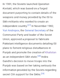
Here is a paragraph copied and pasted from the Wikipedia article "Operation Blue Star". At the time the last war between India and Pakistan was still in fairly recent memory. The KGB forged documentation indicating that Pakistan was supplying the Sikhs with armaments and encouraging them to separate from India. As we might expect the CIA was supposedly in on it too. Indian Prime Minister Indira Gandhi believed what she was told.

Here is another paragraph from the same Wikipedia article "Operation Blue Star". This explains how the forged documentation alleged that Pakistani commandos were infiltrating the border to assist the Sikh separatists.

The distance from earth to Mars is how far India has come since this turmoil of the 1980s. Let's not go back to this. The world looks to India as a world leader. Remember that we saw in the recent posting. "Has India Entered Another Golden Age"? March 2023, that India has a history of having a golden age about every four hundred years, and that means it is due to start the next one right about now.