Wuhan is a centrally-located Chinese city and, as a result, has always been a center for trade throughout the country. It is located on the Yangtze River, one of China's two great rivers with the other being the Hwang Ho, or Yellow River.
Wuchang is one of the three cities that were put together to form Wuhan, to the east of the Yangtze River. This is where the Republic of China began. It was the Wuchang Uprising that led to the end of the Qing Dynasty. Sun Yat Sen returned from exile and became it's president, and the last Qing Emperor abdicated.The revolution that began with the Wuchang Uprising is known as the Xinhai Revolution. There was a provisional government, in a way similar to the October (Russian) Revolution, but this preceded the October Revolution by six years. The Xinhai Revolution is yet another that reflects the French Revolution. Like the French Revolution with it's "Liberte, Fraternite, Egalite", there was Sun Yat Sen's "Three Principles of the People". Like the French Revolution, there were attempts to restore the emperor afterward.
The following scenes, on the Wuchang or eastern side of the Yangtze River, include the Yellow Crane Tower. This tower was first built in the year 223. It has been destroyed, and rebuilt, many times. The current tower was built in the 1980s. The bridge that can be seen in the distance, in some of the images, is the Wuhan Yangtze Bridge. This bridge preceded the one far downstream in Nanjing, that we saw on our visit there. This image of the Yellow Crane Tower is from Google Street View.
There are multiple scenes following. To see the scenes, after the first one, you must first click the up arrow, ^, before you can move on to the next scene by clicking the right or forward arrow, >. After clicking the up arrow, you can then hide the previews of successive scenes, if you wish.
https://www.google.com/maps/@30.5448299,114.3034602,3a,75y,169h,88t/data=!3m8!1e1!3m6!1s-03I2O6-PSKM%2FWSiZ7kSa2rI%2FAAAAAAAASWg%2FdNiNygMAj9Q60Wn1G3TZJ-uG22cQksL9gCLIB!2e4!3e11!6s%2F%2Flh5.googleusercontent.com%2F-03I2O6-PSKM%2FWSiZ7kSa2rI%2FAAAAAAAASWg%2FdNiNygMAj9Q60Wn1G3TZJ-uG22cQksL9gCLIB%2Fw203-h100-k-no-pi-2.9338646-ya266.5-ro0-fo100%2F!7i8192!8i4096
These scenes begin in downtown Wuchang, the eastern side of the Yangtze River. If some of the buildings look Spanish, it is because there is an area that is an imitation of Spain. The first seven images of Wuchang are from Google Street View.
https://www.google.com/maps/@30.5051728,114.4000519,3a,75y,124h,88t/data=!3m8!1e1!3m6!1s-4mAUbtjRsQA%2FVUSqR7YyCfI%2FAAAAAAAAMH8%2FqX_NY8EcPmAF0voE2DIPJBBY3-3ha9OtQCJkC!2e4!3e11!6s%2F%2Flh3.googleusercontent.com%2F-4mAUbtjRsQA%2FVUSqR7YyCfI%2FAAAAAAAAMH8%2FqX_NY8EcPmAF0voE2DIPJBBY3-3ha9OtQCJkC%2Fw203-h100-k-no-pi-2.9999962-ya350.5-ro-0-fo100%2F!7i2509!8i1254
Here is central Wuhan, also on the Wuchang or eastern side of the Yangtze River.
https://www.google.com/maps/@30.559965,114.332672,3a,75y,271h,88t/data=!3m8!1e1!3m6!1s-IZ1cSeIVA8c%2FU9M5itf4IvI%2FAAAAAAAAD9I%2FEoFpcLR81ZMTWHKLZpObB-MRhFbl8miQwCJkC!2e4!3e11!6s%2F%2Flh4.googleusercontent.com%2F-IZ1cSeIVA8c%2FU9M5itf4IvI%2FAAAAAAAAD9I%2FEoFpcLR81ZMTWHKLZpObB-MRhFbl8miQwCJkC%2Fw203-h100-k-no-pi-2.9999962-ya339.5-ro-0-fo100%2F!7i6656!8i3328
This is Hankou, one of the three cities that were originally put together as Wuhan, to the northwest of the Yangtze River. The name of Wuhan appears to have come from combining Wuchang and Hankou. The first four images of Hankou are from Google Street View.
https://www.google.com/maps/@30.5839282,114.2972339,3a,75y,316h,88t/data=!3m8!1e1!3m6!1s-78vf9TYZ1XA%2FWB1GyQeqmjI%2FAAAAAAAAAOQ%2FWvKHK91dm3YKAW2b6gkRKHbbpVfl0Nx4QCLIB!2e4!3e11!6s%2F%2Flh4.googleusercontent.com%2F-78vf9TYZ1XA%2FWB1GyQeqmjI%2FAAAAAAAAAOQ%2FWvKHK91dm3YKAW2b6gkRKHbbpVfl0Nx4QCLIB%2Fw203-h100-k-no-pi-2.9999962-ya317.50003-ro-0-fo100%2F!7i8704!8i4352
The third of the cities that was put together to form Wuhan is Hanyang, which is to the southwest of the Yangtze River. The following four images, from Google Street View, are of Hanyang and of looking across from the Wuchang side.
https://www.google.com/maps/@30.547514,114.2539444,3a,75y,1h,76t/data=!3m8!1e1!3m6!1s-1OTCNeIrmtc%2FV8DpGcP4mwI%2FAAAAAAABdgM%2FteZcwidtmDATwPFq_RSrZUk4D0OWPiIzACLIB!2e4!3e11!6s%2F%2Flh3.googleusercontent.com%2F-1OTCNeIrmtc%2FV8DpGcP4mwI%2FAAAAAAABdgM%2FteZcwidtmDATwPFq_RSrZUk4D0OWPiIzACLIB%2Fw203-h100-k-no-pi-14.933861-ya107.5-ro-0-fo100%2F!7i9728!8i4864
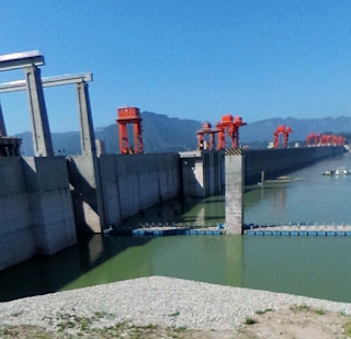
About 300 km, nearly 200 miles, west of Wuhan is the Three Gorges Dam. This was the largest hydroelectric dam in the world. Ships can be lifted right over it. The first two images, from Google Street View, are of the dam.
These two images from Google Earth show how only the central part of the dam, indicated by the red dots, actually generates electricity.
Ships must be raised or lowered, according to their direction, when transversing the dam. Smaller ships can be lifted over the dam by a ship lift. But larger ships must pass through a canal with five locks. In the following image, from Google Earth, the red dot shows the ship lift and the yellow dot shows the lock system in the canal for larger ships.
These two images, from Google Earth and Street View, show the two parallel canals, one for each direction, and a ship passing through at night.
Notice, in the following image from Google Earth, how the doors of the locks, indicated by the red dots, are always constructed so that they open against the direction in which the current would flow, so that it would hold the doors shut.
Here is a look around the Three Gorges Dam.
https://www.google.com/maps/@30.8327617,111.0121,3a,75y,61h,85t/data=!3m8!1e1!3m6!1s-PLlXQSh1ekg%2FVtzSFjrL9nI%2FAAAAAAAABPE%2Fts2LFXQK0GYmLich9pc4hNtz4B58tVp8wCJkC!2e4!3e11!6s%2F%2Flh3.googleusercontent.com%2F-PLlXQSh1ekg%2FVtzSFjrL9nI%2FAAAAAAAABPE%2Fts2LFXQK0GYmLich9pc4hNtz4B58tVp8wCJkC%2Fw203-h100-k-no-pi-5.3020835-ya318.80505-ro0-fo100%2F!7i5376!8i2688
https://www.google.com/maps/@30.8327617,111.0121,3a,75y,61h,85t/data=!3m8!1e1!3m6!1s-PLlXQSh1ekg%2FVtzSFjrL9nI%2FAAAAAAAABPE%2Fts2LFXQK0GYmLich9pc4hNtz4B58tVp8wCJkC!2e4!3e11!6s%2F%2Flh3.googleusercontent.com%2F-PLlXQSh1ekg%2FVtzSFjrL9nI%2FAAAAAAAABPE%2Fts2LFXQK0GYmLich9pc4hNtz4B58tVp8wCJkC%2Fw203-h100-k-no-pi-5.3020835-ya318.80505-ro0-fo100%2F!7i5376!8i2688


No comments:
Post a Comment