Here is a trivia question. What is the capital city of South Africa? Actually, it has more than one capital city because government functions are in different places. But I have always thought that Pretoria was the capital.
The richest man in the world, Elon Musk, is a native of Pretoria.
I wonder what happened to the name of "Azania". After majority rule was achieved there were plans to rename the country as Azania, but then I never read any more about it.
There are multiple scenes following. To see the scenes, after the first one, you must first click the up arrow, ^, before you can move on to the next scene by clicking the right or forward arrow, >. After clicking the up arrow, you can then hide the previews of successive scenes, if you wish.
https://www.google.com/maps/@-25.7402069,28.2119908,3a,75y,90h,90t/data=!3m8!1e1!3m6!1sAF1QipO30Gb0cVVuaqBqgkOMFQaGm2FqU4QGK6F6SAv7!2e10!3e11!6shttps:%2F%2Flh5.googleusercontent.com%2Fp%2FAF1QipO30Gb0cVVuaqBqgkOMFQaGm2FqU4QGK6F6SAv7%3Dw203-h100-k-no-pi-0-ya239.99947-ro-0-fo100!7i10240!8i5120
Nelson Mandela was once imprisoned by the Government of South Africa but now his statue is in front of the Union Buildings. Image from Google Street View.
https://www.google.com/maps/@-25.7461975,28.1878876,3a,75y,115.03h,90t/data=!3m8!1e1!3m6!1sAF1QipNWGCuUJhxpNY0_g7D5-k9nYArH_0KyuUFRf470!2e10!3e11!6shttps:%2F%2Flh5.googleusercontent.com%2Fp%2FAF1QipNWGCuUJhxpNY0_g7D5-k9nYArH_0KyuUFRf470%3Dw203-h100-k-no-pi-0-ya106.403915-ro-0-fo100!7i8192!8i4096
Pretoria West is a small business and residential area. The first image of Pretoria West is from Google Earth.
https://www.google.com/maps/@-25.750317,28.1550944,3a,75y,117.36h,90t/data=!3m7!1e1!3m5!1sOuvs4vrvulvUdPRATlkeAQ!2e0!6s%2F%2Fgeo2.ggpht.com%2Fcbk%3Fpanoid%3DOuvs4vrvulvUdPRATlkeAQ%26output%3Dthumbnail%26cb_client%3Dmaps_sv.tactile.gps%26thumb%3D2%26w%3D203%26h%3D100%26yaw%3D119.87936%26pitch%3D0%26thumbfov%3D100!7i13312!8i6656
This is the area of Pretoria known as Sunnyside. The first image of Sunnyside is from Google Earth.
https://www.google.com/maps/@-25.7536185,28.2082008,3a,75y,78.22h,90t/data=!3m7!1e1!3m5!1sA1gr12X7C6bRLYL2SdJdQw!2e0!6s%2F%2Fgeo3.ggpht.com%2Fcbk%3Fpanoid%3DA1gr12X7C6bRLYL2SdJdQw%26output%3Dthumbnail%26cb_client%3Dmaps_sv.tactile.gps%26thumb%3D2%26w%3D203%26h%3D100%26yaw%3D76.9685%26pitch%3D0%26thumbfov%3D100!7i13312!8i6656
To the north of the city center is the residential area of Rietfontaine.
https://www.google.com/maps/@-25.7054583,28.2197334,3a,75y,226h,87t/data=!3m7!1e1!3m5!1s0T_b10Yliodk-VjOPAKazA!2e0!6s%2F%2Fgeo0.ggpht.com%2Fcbk%3Fpanoid%3D0T_b10Yliodk-VjOPAKazA%26output%3Dthumbnail%26cb_client%3Dmaps_sv.tactile.gps%26thumb%3D2%26w%3D203%26h%3D100%26yaw%3D226.5%26pitch%3D-3%26thumbfov%3D100!7i13312!8i6656
The following scenes begin inside the Voortrekker Monument. The structure is built so that, every December 16, a ray of sunlight illuminates the cenotaph on the lower level, and only on that date. The way it is arranged, so that viewers on the upper level can look down on the cenotaph, may remind you of Napoleon's Tomb in our visit to "Paris".
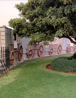
The wagons around the wall on the outside, designed to resemble Egyptian hieroglyphics, are to remember the pioneers, known as Voortrekkers, who journeyed inland away from British rule, to establish Afrikaner territories. This led to such states as the Transvaal and Orange Free State, which became part of the Union of South Africa, which left the Commonwealth and became the Republic of South Africa. As you can see, Afrikaners are fond of monuments and statues. This trek into the interior of the country is reminiscent of that of the Mormons, in the U.S.
The Voortrekker Monument could be thought of as South Africa's pyramid. The clear Egyptian influence is meant to resonate with that great ancient civilization, far away at the other end of Africa. This monument is the new pyramid of Africa, dedicated to the God of Christianity. The first three images of the Voortrekker Monument are from Google Earth and Street View.
The reliefs at the monument, both inside and outside, are of the Voortrekker move into the interior of Africa so that they could build their promised land. In these four images from Google Street View you can see how this looks like something out of ancient times and evokes the move of the Israelites away from bondage toward their promised land.
This movement into the interior of Africa resulted in the founding of the Transvaal and Orange Free State as Boer republics. "Boer" is the Afrikaans word for "farmer". The name of the Orange Free State ultimately comes from the Dutch royal House of Orange. The Dutch also settled eastern New York State. This is why there is an Orange County in New York State, Albany was originally called Fort Orange and the sports teams of Syracuse University are today called the Orange. It is also where the orange on the Irish flag originated.


No comments:
Post a Comment