Thursday, April 24, 2025

Persepolis

Persepolis was the capital of the original Iranian empire, known as the Achaemenid Empire. This capital was moved here from Pasgardae. Iran has had four separate empires during it's long history, and this was the first. Persia, the former name of Iran, was a great power, having conquered both Babylon and Egypt.

This is the empire that is described in the Bible as conquering Babylon and allowing the Jews, who had been taken captive and resettled there, to return to Israel and rebuild the Temple, which the Babylonians had destroyed. 

Persepolis made history in modern times. In 1971 the Shah of Iran held a lavish party in the ruins of Persepolis. It was to celebrate the 2500th anniversary of the Persian Monarchy. It was possibly the greatest party that the world had ever seen. The guests didn't know it at the time but the Shah would be the final monarch. He would be overthrown, and the monarchy would be abolished, by the Islamic Revolution of 1979.

These fourteen images of the ruins of Persepolis are from Google Street View.


The India-Pakistan Border

About every few years some incident happens between India and Pakistan that brings the two countries close to war. But there is more than local politics at work. This is a matter of global history. Whenever there is a troublesome border, there is virtually always a long history behind it.

We saw in the posting "Understanding The World In Terms Of The South And West And The North And East" that the world can be divided into two halves that operate differently. The operation of each half is ultimately based on religion. The South And West is based on the monotheistic religions, primarily Christianity and Islam. The North And East is based on the eastern religions, primarily Hinduism and Buddhism. In the North And East, mostly the same nations have existed since ancient times. While in the South And West, new nations come into existence with new ideas.

The border between India and Pakistan is far more than just the border between the two countries. As we saw in that posting, it is also where the two halves of the world meet. This explains the conflict.

Here is a link to the posting.

www.markmeeksideas.blogspot.com/2016/04/understanding-world-in-terms-of-south.html?m=0

Our Counter-Clockwise World

When I am in line at a supermarket checkout I think about stuff like this.

For clocks, we have chosen that the hands will move what we now call clockwise, rather than counter-clockwise. But have you ever wondered why we don't have everything else lined up with this? 

On maps we put north at the top. But this is just done by convention and there is no reason why any of the other directions couldn't have been at the top. But this causes maps and globes not to line up with our clockwise direction.

ALL IMAGES FROM GOOGLE EARTH

The earth rotates eastward so that, if we look down on it from above the north pole it is rotating counter-clockwise.

But if we look down from above the south pole it is rotating clockwise. Doesn't this mean that south should be at the top on maps and globes, or that the hands of a clock should move in the opposite direction?

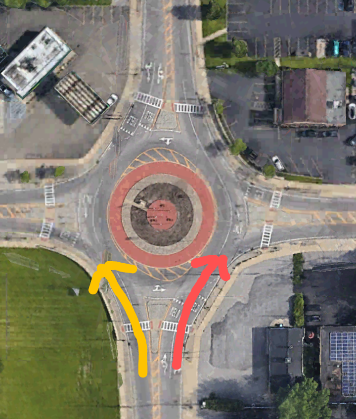
About two-thirds of the world's population lives in countries that drive on the right side of the road. But this means that they drive counter-clockwise through a traffic circle, as shown by the red arrow in the following image. Drivers on the left do go clockwise through the traffic circle, as shown by the yellow arrow.

Part of the reason for passing on the left, which brings about the clockwise direction, is a violent history. Most people are right-handed so if accosted by someone passing, it is better to have the right hand forward to more easily use a sword or a pistol. I believe that this is why the clockwise direction was subconsciously chosen for clocks.

I wonder if we will ever get everything all lined up.

The Numerology And Geometry Of The Catholic Church

With the world's attention on the Catholic Church, let's review the numerology and geometry associated with it that has not been seen before.

1) THE NUMEROLOGY OF THE SPLITS IN THE CATHOLIC CHURCH 

Let's first review the connection between the two destructions of the Israelites' temple in ancient times and the two major splits in the Christian Church in more modern times.

The original temple, at Shiloh, was destroyed by the Philistines in 1050 B.C. Shiloh was never rebuilt because it was replaced by Solomon's Temple, in Jerusalem. That temple was destroyed by the Babylonians, ruled by King Nebuchadnezzar II who then took the Jews into exile. The Babylonian siege of Jerusalem that resulted in the destruction of the Temple began in 587 B.C.

From 1050 B.C. to 587 B.C. is 463 years.

The Book of Daniel, Chapter 9, has the famous "weeks of years" prophecy. There are to be 70 weeks of years, 70 x 7 = 490. But one of those weeks is reserved for the seven years that the Antichrist will be allowed to reign. That leaves 483 years.

These 69 "weeks of years" refers to the time between the completed reestablishment of the Temple, the so-called Second Temple after return from the exile in Babylon that replaced Solomon's destroyed temple, to the death of the promised Messiah. This was marked by Ezra being sent to Jerusalem to instruct in proper worship in the newly-completed temple. The biblical Book of Ezra describes this.

The date that Wikipedia gives for the sending of Ezra to Jerusalem is 457 B.C. Jesus was almost certainly crucified in 26 A.D., being born in 7 B.C. and believed to be 33 years old at crucifixion. This is amazing. From 457 B.C. to 26 A.D. is exactly 483 years.

Now, let's go to more recent times. There have been two major splits in the Christian Church. The first was the Great Schism of 1054 that resulted in the splitting of what is today the Eastern Orthodox Church from the Catholic Church. The second is the split of the Protestants from the Catholics, due to the Reformation that began in 1517.

Jesus is to return, to end the reign of the Antichrist and establish the Millennium, when the world will finally be the godly paradise that it was always intended to be. No one knows the exact day but a secular millennium began in 2000 which is during the general timeframe as we see in the posting on this blog, "The End Of The World As We Know It".

What I noticed one day is that from 1054 to 1517 is 463 years, and from 1517 to 2000 is 483 years.

No one had ever pointed that out. I refer to it as "The Ancient-Modern Parallel". It is described in section 25) of "The Aztec Prophecy", on this blog, and I thank God that I was the one that was allowed to notice this.

CONSTANTINOPLE AND THE HOLY ROMAN EMPIRE

With that review here is what I noticed to add onto it. I find this to be absolutely amazing.

Constantinople was founded in the year 330 by the Roman Emperor Constantine as the capital of the eastern half of the Roman Empire. It would later be the place where the split, known as the Great Schism of 1054, would take place. This is when the eastern domain of the Catholic Church would split away to form the Eastern Orthodox Church. This is one of the most momentous events in western history. After that, in 1453, Constantinople would be conquered by the Ottomans and renamed as Istanbul.

From the founding in 330 to the split of 1054 is 724 years.

The Holy Roman Empire was founded by the pope in the year 800. Charlemagne was crowned as it's first emperor. The purpose of the Holy Roman Empire was to rein in the wayward eastern Christians, who were questioning the authority of the pope and would later split away to form the Eastern Orthodox Church. Despite the name the Holy Roman Empire was more centered on what is now Germany and would become more of a rival to the papacy than an ally. In 1517 the second great split in the Catholic Church, the Protestant Reformation, began in the Holy Roman Empire over the urgent need for reform in the church.

From the founding in 800 to the split of 1517 is 717 years.

What do you notice here about the times between each founding and split? The two figures, 724 and 717 are close but there is a 7 year difference. Just like the "Weeks of Years" prophecy in the Bible described above, there are still seven to go for the Holy Roman Empire. We know that the Antichrist's base of operations will be a united Europe, which is a reviving of the Holy Roman Empire. These remaining seven years will be the seven years that the Antichrist is allowed to reign, as described in the Book of Revelation.

I find this to be absolutely amazing and again I thank God that I was allowed to be the one to point it out.

THE CRAB NEBULA AND THE GREAT SCHISM OF 1054

Another thing that I was amazed had never apparently been noticed is that the great explosion in the sky that formed what we now see as the Crab Nebula was taking place just as the conference in Constantinople was going on, in 1054, that would lead to the splitting away of the Eastern Orthodox Church from the Catholic Church. July 4, 1054.

The Crab Nebula today is considered as the classic example of a supernova remnant. At the time, the explosion was so brilliant that it shone brightly even in the daytime. Could it have been a warning from God of the trouble that was coming because the east-west divide ever since, from the Eastern Front of the two world wars to the nuclear standoff during the Cold War, were secular manifestations of that split. This is described in section 1) of "The Aztec Prophecy".

But, as far as I could find online, it had never been pointed out that this great explosion in the sky was going on at the same time as the ill-fated conference in Constantinople and, once again, I thank God that I was the one to be allowed to point it out. it doesn't seem that Europeans paid much attention to the supernova, although it was recorded by Arab, Chinese and, Japanese observers.

2) THE GEOMETRIC RELATIONSHIP BETWEEN THE VATICAN AND ANCIENT ROME 

ST. PETER'S SQUARE IS OF THE SAME SHAPE AND DIMENSIONS AS THE COLOSSEUM 

The Vatican has been set up in secret alignment with the Colosseum and Arch of Titus, on the other side of Rome. This has never been pointed out.

Have you ever wondered why St. Peter's Square, at the Vatican, is actually shaped like an oval?

As it turns out there is a simple answer. I cannot find anything about this being documented but am not quite sure whether to believe that I am the only one today that knows this.

St. Peter's Square, inside the Colonnades, is exactly the same size and shape as the Colosseum, which is about 3.5 km away. This is St. Peter's Square. St. Peter's Basilica is to the left so that the two together have the shape of a key, with the oval form of the "square" being the handle of the key.

Image from Google Earth

Here is the Colosseum, shown from the same altitude. Although the directional alignment of the two is not the same, you can use Google Earth and select the "Measure Distance" feature to see that the dimensions of the Colosseum are exactly that of the internal diameter of the Colonnades that give St. Peter's Square it's oval form. Part of the structure of the Colosseum along it's long axis is missing but both measure about 190 meters, or 625 feet.

Image from Google Earth

The oval form of both is not an extreme ellipse, the ratio of the long axis to the short axis being about 1.2 or 6/5.

Clearly, St. Peter's Square was constructed to exactly match the Colosseum but this has never been made public.

THE CENTER OF ST. PETER'S SQUARE IS LOCATED EXACTLY ON THE LONG AXIS OF THE COLOSSEUM, AND ALSO THE LATERAN PALACE

There is more to the hidden relationship between St. Peter's Square and the Colosseum. By using the "Measure Distance" option on Google Earth, it draws a straight line between the two points that are clicked on. If we choose the first point as the obelisk in the center of St. Peter's Square and the second point as the far side of the long axis of the Colosseum, the southeastern end, we find something else amazing that has never been made public.

The direction to St. Peter's Square from the Colosseum is exactly along the extension of the long axis of the oval form of the Colosseum.

So St. Peter's Square was not only constructed to match the dimensions of the Colosseum, it was also located to be aligned with the long axis of the Colosseum, although the directional alignment between the two is not the same.


Images from Google Earth

That is not all. The original center of the Catholic Church was not the Vatican, as it is today, but the Lateran Palace. The papacy moved, for some time, to Avignon in southern France. When it returned to Rome, the Lateran Palace had been damaged by fire and was relocated to the Vatican instead. The Lateran Palace is still officially the headquarters of the church.

As it turns out the Lateran Palace is located on the opposite side of the Colosseum, which is from ancient Rome and was built before either, from the Vatican. This means that the Lateran Palace was also located on the extension of the long axis of the Colosseum, but in the opposite direction to that of the Vatican with St. Peter's Square.

The Lateran Palace is a large complex, but that means that we can draw a straight line with the Google Earth "Measure Distance" feature from the obelisk in St. Peter's Square to a point in the Lateran Palace complex, and the line will go right along the long axis of the Colosseum.

But what could these alignments mean? It is reminiscent of the Historical Axis of Paris, but that is no secret. I have searched and searched and cannot find that this alignment in Rome has ever been made public. The Colosseum is the best-known structure from ancient Rome, is the symbol of the modern city of Rome as well as it's geographical center.

It seems clear that this alignment with the Colosseum is an effort by the church to link itself with the power of the Roman Empire, but not to be made public. It could be a symbolic sympathy for those Christians who were martyred by the Roman Empire but it is not clear how many were martyred at the Colosseum, as opposed to the nearby Circus Maximus.

THE CENTER OF THE DOME OF ST. PETER'S IS ON THE AXIS THROUGH THE ARCH OF TITUS

Putting down the Jewish uprising against Roman rule, which resulted in the destruction and looting of the Temple, had not been an easy battle for the Romans. When it was over, the Arch of Titus was built next to the Colosseum, to memorialize the victory. The engravings on the Arch illustrate the wealth being taken from the Temple which went to build the adjacent Colosseum.

Jews who visit Rome are not supposed to walk under the Arch of Titus.

The amazing thing is that there is not only the above described axis, through the long axis of the Colosseum, there is also another axis that runs close-by and parallel to it. The center of the dome of St. Peter's Basilica is located exactly on the axis that runs through the Arch of Titus.


Images from Google Earth

Thursday, April 17, 2025

Donald Trump And BRICS

Something that I haven't yet seen written about the second term of Donald Trump is the effect that it will have on BRICS. This is the global economic organization that was formed primarily as a backlash to the dominance of the U.S. Dollar. The knock against BRICS is that it's member nations are so diverse and far apart, with their only thing in common being the opposition to Western dominance. But now the protectionism of Donald Trump might be the greatest thing that ever happened to BRICS.

A major recent development in the world is the growth of interest in BRICS. This is an organization of non-western countries. The acronym stands for Brazil, Russia, India, China and, South Africa, but many more countries have joined or expressed interest in it.

The best-known international organization is the G7. It consists of the U.S., Canada, Britain, Germany, France, Italy and, Japan. But the G7 has become, in much of the world, a symbol of past western domination that is not at all reflective of the world today.

The G7 was later expanded into the G20, although the G7 exists separately. But the G20 is still considered by much of the world as too tilted toward the west.

BRICS professes no hostility toward the west. But it is seen as the "Non-West", an organization of countries across the world that appear to have little in common other than a wish to move beyond western domination of the world.

A major objective of BRICS involves currency. The U.S. Dollar is the dominant reserve currency in the world. This goes back to the Bretton Woods agreement from just before the end of the Second World War, with the U.S. taking advantage of it's dominant position at the time. Richard Nixon took the U.S. off the Gold Standard, effectively ending the agreement, but by then the dollar had the momentum as by far the world's most important reserve currency.

The issue in the world today is that this gives the U.S. the ability to enact economic sanctions against other countries. The number one target of U.S. sanctions has been Iran, and also Venezuela, but now the main target is Russia. There is increasing resentment of this ability to impose sanctions on other countries, and the formation of BRICS can be seen as somewhat of a backlash. 

There is another way to describe the war in Ukraine that I have not seen. It could be called the BRICS War.

The following image is from the Wikipedia article "BRICS".

Virtually all of the harsh condemnation of Russia for the war, and assistance and praise for Ukraine, have come from western countries that are not members of BRICS. Some BRICS member states have called for peace, and offered to meditate negotiations, but have not directly condemned Russia's war effort. 

This doesn't necessarily mean that BRICS members actually support the war, just as westerners vary in their support for Ukraine, but this war could well be called "The BRICS War". 

The major obstacle to the BRICS movement is that it's membership is so diverse and scattered across the world. The only thing that they really have in common is the desire to undercut the dominance of the West. The central issue of BRICS is currency, to reduce the dominance of the U.S. Dollar as the world's reserve currency.

There is another organization that is somewhat of a parallel to BRICS, the Shanghai Cooperation Organization, but it's primary focus does not seem to be economic, in the same way as BRICS.

There is nothing innately special about the U.S. Dollar or anything written in stone that it has to be the world's reserve currency. It's just that it has momentum in it's favor and people have confidence in it. The creation of an entirely new currency by BRICS has been discussed but it seems more likely that there will be more emphasis on using existing currencies. 

The creation of a joint currency inevitably involves member nations giving up some of their sovereignty, in that they can no longer print their own money at will. The Euro is the world's foremost joint currency and, although it is working well in Europe it hasn't displaced the Dollar as the global reserve currency.

For a nation's currency to be a global currency it must be completely convertible and must be allowed to "float" freely in value against other currencies. The world's two most populous countries are both members of BRICS. But China doesn't allow the Yuan to float completely freely. This risks allowing it's value to be determined by forces outside the country, including currency speculators.

India does not allow the Rupee to be readily convertible into other currencies. Making the currency completely convertible is taking a risk, it exposes the country to potentially volatile capital flows, including the money leaving the country. The Dollar is the world's reserve currency because the U.S. Government has been willing to take these risks.

Some have thought that maybe cryptocurrencies, such as Bitcoin, might provide a global currency. But a global currency must be stable, without great swings in value. The value of a currency operates by supply and demand, and global use of the U.S. Dollar keeps it's value relatively stable. When using a foreign currency, if it's value increases that makes a country's exports more expensive and increases the amount of real money that has to be repaid for debts. If it's value decreases that decreases a country's spending power, although it makes it's exports less expensive.

BRICS cannot be ignored. With it's new members it has close to half of the world's population, and many more countries want to join. But what it has to realize is that a global currency must be allowed to freely float in value and be freely convertible into other currencies. There are fewer than 20 currencies that are completely convertible, including the U.S. and Canadian Dollars, the Euro and the British Pound. Most governments are uneasy about completely removing restrictions on how their currency relates to foreign currencies.

I haven't seen anything about it yet but the protectionism of Donald Trump is a reversal of the global economic order. This changes everything about the global dominance of the U.S. Dollar and might be the greatest thing that ever happened to BRICS.

The Nationalization Of British Steel

The Nationalization Of British Steel was announced this week. The government is taking it over to prevent it's being shut down because the ability to make steel, aside from recycling existing steel, is considered as vital to national security.

I wonder what Margaret Thatcher would think. She was the conservative prime minister who sold off the state-owned industries to the private sector, considering it as more efficient. Now that is being reversed with re-nationalization. 

We saw the issue of steel production and national security in the posting about Margaret Thatcher after her death: www.markmeekeconomics.blogspot.com/2013/08/margaret-thatcher-in-perspective.html?m=0

The concept of the free market is based on the Law of Supply and Demand, and letting everyone do what they do best. But it is a rather simplistic model that doesn't always fit with the real world.

One of those ways is that countries don't always get along with each other. The free market model allows processes to move to other countries, if that means increased efficiency. But that presumes that the world is a level and fair playing field. Profit is not the only motive, there is also national security. Steel is absolutely essential to a nation's ability to protect itself, and is detrimental to national security if there is no steel-making capacity, even if the move offshore might be more economically efficient.

The way I see politics and economics is that it is a 360 degree picture. Our economics are necessarily just as complex as we are. That makes it easier for each of us to just see either the right, supply side, or left, demand side, rather than the entire picture. This means that both sides have valid points, but each has difficulty seeing the other's point of view.

Let's review my view of the leftist theories of Karl Marx.

THE MARX CLOUD 

I have a new way of looking at the theories of Karl Marx. I conclude that the fulfillment of Marxist theory can be seen in, of all things, computer technology. Since the end of the Cold War, Marx has been viewed as one of the great losers of history. He was nowhere near completely right in his predictions, yet was on to something and cannot be ignored. When I was in London, I thought of visiting his grave in Highgate Cemetery but never got around to it.

The workers of the world did not unite and take over the means of production, as Marx had envisioned. But he was somewhat vindicated by the crash of Capitalism in 1929, as well as the somewhat lesser crashes of 1987 and 2008. He might have been pleased with the implementation of minimum wage and workplace safety laws, labor unions, unemployment benefits and social security, and especially mandatory public education. All of which, with the exception of labor unions, was virtually unheard of in the Nineteenth Century when Marx wrote his theories. 

Samuel Gompers could be seen as America's reflection of Marx. Religion, the "opiate of the masses" certainly has not faded away as expected by Marx. But it is true that the western countries, at least, are more secular than they were in the days of Marx.

We look at the theories of Marx in socio-economic terms. But what if there was another side to the theory, that of technology, even if Marx himself did not see this? Some of the fulfillment of Marxist theory certainly was in the socio-economic sphere, as the above mentioned reforms. But the other side, the technical side and it's global social effects, had to wait for the advent of computers and the internet.

Computer and phone technology has empowered the masses like nothing else, even though it is produced by companies owned by wealthy capitalists. Wikipedia, for one, seems to be straight from the pages of Marxist theory. It is the collective encyclopedia of the masses, operated by donations and open to anyone who wishes to contribute. All free apps on the internet, open to all and not driven by profit motive, also fall into this category.

The nation-state has not faded away, at least not in the way that Marx supposedly envisioned. In the more than century and a half since the days of Marx, nationalism has been stronger than ever before. My theory is that people are designed to believe in something and if they drift away from religion, substitutes like nationalism will take it's place.

But yet national borders also mean less today than ever before. Trade and travel goes around the world. It is possible to wake up in any country one morning, and go to bed in any other country that night. You can log onto a web site, or make a call, or send an email virtually anywhere on earth, with the national borders in between being absolutely meaningless.

But the latest manifestation of Marxist theory is this phenomenon of collective global internet, known as "the cloud". The basic meaning of the cloud is that the data that you store, and increasingly the applications that you use, are not stored on your computer but are "out there somewhere" in the cloud. This blog is an ideal example of the cloud. It is not stored on my computer. I presume that the content of this blog is kept at Google's HQ in Mountain View, California, but could be on any server farm anywhere.

Marx sensed what would come. The Nineteenth Century in Europe was a time of revolution, and he presumed that the inevitable changes that he saw would be brought about in the same way. We could say that half of the fulfillment of his theory was by way of the social reforms listed above. But the communication technology of the time was limited to telegraphs relaying Morse Code. Marx could not possibly have imagined the computer revolution which would one day manifest the other half of this fulfillment.

He also did not see that while the technical side of his theory would be fulfilled, and it would greatly empower the masses that Marx saw as exploited and ill-treated, it would be brought about by very wealthy capitalists. The difference, with which Marx would be at least partially pleased, is these capitalists would not be from an entrenched upper class, but would be college kids who got an idea, quit school to work on it, and found themselves as the billionaires which would, ironically, bring about the remaining fulfillment of Marxist theory.

This shows what Karl Marx actually envisioned. He was right but he only saw half of the picture and it would require advancement in technology, which would take time, to bring his half of the picture about.

My observation is that the best economic model is not one that is right or left, but the one which best weaves right and left together.

Thursday, April 10, 2025

Northern Iran

We have already visited Tehran. This visit will be to the cities of Tabriz, Karaj, Qom and, Mashad.

The major city of northwestern Iran is Tabriz. It's primary language is Azerbaijani. Tabriz is an ancient city that was a link in the Silk Road. It is especially known for it's historic bazaar. The following scenes begin in the Bazaar. The first six images of the Bazaar are from Google Street View.


This Bazaar is an ideal place to shop for traditional Persian carpets.


Portraits of the ayatollahs are very often seen. Khomeini is on the right and Khamenei on the left.

There are multiple scenes following. To see the scenes, after the first one, you must first click the up arrow, ^, before you can move on to the next scene by clicking the right or forward arrow, >. After clicking the up arrow you can then hide the previews of successive scenes, if you wish.

https://www.google.com/maps/@38.0807483,46.2922475,3a,75y,76.45h,90t/data=!3m8!1e1!3m6!1sAF1QipO6b9nmQRUqv5iHSu_5n1a8PCQQHkUcM6-9KcWD!2e10!3e11!6shttps:%2F%2Flh3.googleusercontent.com%2Fp%2FAF1QipO6b9nmQRUqv5iHSu_5n1a8PCQQHkUcM6-9KcWD%3Dw900-h600-k-no-pi0-ya74.33245203319255-ro0-fo100!7i7680!8i3840?entry=ttu&g_ep=EgoyMDI1MDEyMS4wIKXMDSoASAFQAw%3D%3D

Another historic sight in Tabriz is the Blue Mosque. This doesn't look like a Shiite mosque, which tend to be more colorful. But remember that it was the Safavid Dynasty that forcibly converted Iran from Sunni to Shiite in the Eighteenth Century, and this mosque was built before then. The first five images are from Google Street View.


The following images are of the area around the Blue Mosque.

https://www.google.com/maps/@38.0734046,46.3010152,3a,75y,352.7h,90t/data=!3m8!1e1!3m6!1sAF1QipOutEGAQXa6CmNd2pnkL2Lw0zzrmI-s-2jE3Kqx!2e10!3e11!6shttps:%2F%2Flh3.googleusercontent.com%2Fp%2FAF1QipOutEGAQXa6CmNd2pnkL2Lw0zzrmI-s-2jE3Kqx%3Dw900-h600-k-no-pi0-ya159.94311176222863-ro0-fo100!7i4096!8i2048?entry=ttu&g_ep=EgoyMDI1MDEyMS4wIKXMDSoASAFQAw%3D%3D

Karaj is a city to the west of Tehran. It is known for the Suleymanieh Palace. This was a palace of the Qajar Dynasty. This was the dynasty that preceded the Pahlavi Dynasty, which was the final dynasty before the Islamic Revolution ended the monarchy in 1979. It was the Qajar Dynasty that made Tehran the capital of the country. The palace has murals of the Qajar Dynasty royal family. The following three images are from Google Street View.


Here is a look around central Karaj. The first three images are from Google Street View.


https://www.google.com/maps/@35.844212,50.971883,3a,75y,320h,90t/data=!3m8!1e1!3m6!1sAF1QipOkzhQUfQps2ASecgVH_Ehafb3NJ0ya667xd5ij!2e10!3e11!6shttps:%2F%2Flh3.googleusercontent.com%2Fp%2FAF1QipOkzhQUfQps2ASecgVH_Ehafb3NJ0ya667xd5ij%3Dw900-h600-k-no-pi0-ya217.3446960449219-ro0-fo100!7i5760!8i2880?entry=ttu&g_ep=EgoyMDI1MDEyMS4wIKXMDSoASAFQAw%3D%3D

Qom is considered as a holy city of Shia Islam. Much of the life of Ayatollah Khomeini revolved around this city. The reason that the original Shia cities are in Iraq, Najaf and Kufa, is that Iran was only converted to Shia Islam, from Sunni, by the Safavid Dynasty in the Eighteenth Century. Qom is a very old city that, previous to becoming a holy city, has been a part of all of the empires that have controlled the region.

The central sight of Qom is the spectacular Shrine of Fatima Masumeh. She was the daughter of one of the Twelve Imams revered by Shiite Moslems, and the sister of his son and following Imam. The daughter of Muhammad was also named Fatima.

Here is the Fatima Masumeh Shrine. The first ten images are from Google Street View. 


https://www.google.com/maps/@34.6534483,50.8401386,3a,75y,121.72h,90t/data=!3m8!1e1!3m6!1sAF1QipOkDyirJW20TOqG7wfQeFdc2KiNyAWElszjd6B8!2e10!3e11!6shttps:%2F%2Flh3.googleusercontent.com%2Fp%2FAF1QipOkDyirJW20TOqG7wfQeFdc2KiNyAWElszjd6B8%3Dw900-h600-k-no-pi0-ya262.72269114151584-ro0-fo100!7i8704!8i4352?entry=ttu&g_ep=EgoyMDI1MDEyMS4wIKXMDSoASAFQAw%3D%3D

Also in Qom is the Imam Hasan Askari Mosque, with the "swirl" pattern dome. These three images are from Google Street View.


Another notable sight in Qom is the Mosque of Jamkaran. These four images are from Google Street View.


Mashad is the major city in the northeastern corner of Iran. Along with Qom, it is considered as a holy city of Shia Islam. It is a very old city that existed long before Islam, having been a stop on the Silk Road. The most important place in Mashad is the Shrine of Imam Reza. This includes the tomb of one of the twelve successive Imams revered by Shiite Moslems.

This is the Shrine of Imam Reza. The first seven images are from Google Street View. The fourth image looks like a model of the Dome of the Rock.


Also in Mashad is the Tomb of Nadir Shah, with a statue of him on a horse. This was a great conqueror who was like the Persian version of Napoleon or Alexander the Great. Image from Google Street View.

This is a look around the city of Mashad. This first three images are from Google Street View.


https://www.google.com/maps/@36.3051188,59.5730462,3a,75y,200h,100t/data=!3m8!1e1!3m6!1sAF1QipP99XCS4XfR8RxvB18Mw1LFIemOKIwX5aPtiUvw!2e10!3e11!6shttps:%2F%2Flh3.googleusercontent.com%2Fp%2FAF1QipP99XCS4XfR8RxvB18Mw1LFIemOKIwX5aPtiUvw%3Dw900-h600-k-no-pi-10-ya11.265213012695312-ro0-fo100!7i3840!8i1920?entry=ttu&g_ep=EgoyMDI1MDEyMS4wIKXMDSoASAFQAw%3D%3D

Here is more of the city of Mashad. This is the largest city in Iran after Tehran.

https://www.google.com/maps/@36.2699282,59.6108163,3a,75y,110t/data=!3m8!1e1!3m6!1sAF1QipNdnaNV-BVlBnG1iboTUPVI5p1hL3AUmpGOuD5H!2e10!3e11!6shttps:%2F%2Flh3.googleusercontent.com%2Fp%2FAF1QipNdnaNV-BVlBnG1iboTUPVI5p1hL3AUmpGOuD5H%3Dw900-h600-k-no-pi-20-ya50-ro0-fo100!7i5300!8i2650?entry=ttu&g_ep=EgoyMDI1MDEyMS4wIKXMDSoASAFQAw%3D%3D