This visit will be to the cities of Isfahan, Yazd, Shiraz and, Zahedan.
Isfahan was the capital of Iran during the Safavid Dynasty. This was the dynasty that converted the country from Sunni to Shiite Islam. The final dynasty of Imperial Iran was the Pahlavi Dynasty that was overthrown in the Islamic Revolution of 1979.
Isfahan is centered around a great square. The square is called Naqsh-e Jahan Square. On each side of the square is an important element of the city.
On the north side of the square is an old gate, the Qeysarie Gate. The following image is from Google Street View.

The gate leads, from the square, to the vast bazaar that Isfahan is known for. This is a traditional Iranian bazaar. The following three images of the Bazaar are from Google Street View.


On the west side of the square is a palace, from the Safavid Dynasty era. This is the Aali Qapu Palace. The following two images, of the outside and inside of the of the palace, are from Google Street View.


On the East side of the square is the Sheikh Lotfollah Mosque. The following five images of the mosque are from Google Street View.


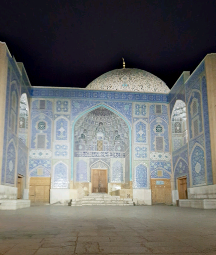


At the southern end of the square is the Shah Abbasi Mosque. The following three images are from Google Street View.


Here is a look around the square and general area.
There are multiple scenes following. To see the scenes, after the first one, you must first click the up arrow, ^, before you can move on to the next scene by clicking the right or forward arrow, >. After clicking the up arrow you can then hide the previews of successive scenes, if you wish.
The following scenes of Isfahan begin along the famous now-pedestrian Chahar Bagh Street.
This is more of the city of Isfahan.
Yazd is the very historic city around the geographical center of Iran. The old part of Yazd is made of brick and adobe, with domes and courtyards. In this aerial image, from Google Earth, you can see all the small courtyards.

These three images, from Google Street View, show what traditional architecture in Yazd looks like.


This is the Amir Chaghmagh Complex, in the old part of Yazd. The first two images are from Google Street View.


This is the Jameh Mosque, and surroundings. The first seven images are from Google Street View.


Yazd has an extensive traditional bazaar, the Yazd Khan Bazaar. The first two images are from Google Street View.


The following image, from Google Street View, is of a Zoroastrianism temple in Yazd. Iran has been Islamic for about half of it's long history. The primary religion from ancient times until then was Zoroastrianism, which is a form of monotheism. The Wise Men who brought gifts to the baby Jesus, described in the Gospel of Matthew, were almost certainly Zoroastrians. They are known as the Magi.

This is the newer part of Yazd, in the southern area of the city.
Shiraz, like many of the major cities in this ancient country, was once the capital of Iran. The city goes back to ancient times. What Shiraz is known for is the Shah Cheragh, which means "King of Light". This is a Twelfth Century mausoleum and mosque. The interior mirror work is absolutely amazing. This may be the best use of mirrors in the world. These eleven images of the Shah Cheragh are from Google Street View.


Shiraz has a traditional bazaar. The first images of the Bazaar are from Google Street View.


Here is more of the central area of Shiraz.
Shiraz is not all historic. The following three images, from Google Street View, are of an industrial park to the south of the city. Iran is one of the most mountainous countries in the world and you can see the mountains in the background.


This is the modern northern part of Shiraz.
In the general area of Shiraz is the site of Pasgardae. This was the original capital of the first Iranian (Achaemenid) empire. The capital of this first empire was later moved to Persepolis. Iran has had four separate empires during it's long history. These two images are from Google Street View. The stone structure is the Mausoleum of Cyrus. The Persians were a vassal state of the Medes, but Cyrus turned the tables so that the Persians were the rulers of the two. Cyrus was the beginning of the Persian Monarchy that would last for 2,500 years, until the Islamic Revolution of 1979.


In southwestern Iran, at Susa, is what is considered to be the tomb of the biblical prophet Daniel. It is not the only place that is claimed to be his tomb, but seems to be the most widely accepted.


In the far eastern part of Iran, near the border with Pakistan, is the city of Zahedan. This is a newer city, by the standards of this part of the world, so it does not have a long history to go over. But one thing that I find striking about the city is the Makki Mosque. All the way out here it is a virtual copy of the Hagia Sophia that we saw in the compound posting, "The House Of Holy Wisdom, Where The Modern World Began", January 2016.
These two images, from Google Street View, are of the Makki Mosque.


Here is a look around the central part of Zahedan.
I have long thought that the idea of smokestacks comes from minarets. The stacks of the old Battersea Power Station, in London, make it look as if it could have been a mosque. Two images from Google Street View.


No comments:
Post a Comment